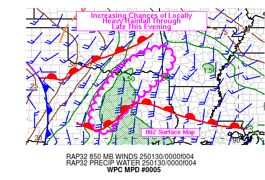
Mesoscale Precipitation Discussion 0005
NWS Weather Prediction Center College Park MD
845 PM EST Wed Jan 29 2025

Areas affected...Parts of North Texas and Southeast Oklahoma

Concerning...Heavy rainfall...Flash flooding possible

Valid 300144Z - 300644Z

SUMMARY...Increasing shower and thunderstorm activity is underway
and is expected to continue into the late evening across portions
of northern Texas and southeast Oklahoma which results in an
increasing risk of flash flooding through 0630Z.

DISCUSSION...Composite image of area 88D reflectivites from early
this evening showed shower and thunderstormn activity growing in
areal coverage with embedded heavy rainfall already moving through
portions of the urbanized Dallas-Ft Worth metropolitan area.
Given the approach of a trough in the southern stream along with a
surface cold front...the trend for increasing coverage and
rainfall intensity is expected to continue through at least 0630Z
leading to increased risk of flash flooding.

Recent HRRR runs and the 18z HREF are supportive of increasing
coverage of showers and thunderstorms overnight as low level flow
becomes southerly in the 20 to 35 kt range and begins to draw
moisture northward from the Gulf.  However...the models have
already been proven to be too slow to develop heavy rainfall
rates. Rainfall rates from the most active convection should
generally be in the 1 to 1.5 inch range although isolated 2 inch
per hour rates can not be entirely ruled out with some potential
for 2 to 4 inches possible.

Concern for flash flooding is greatest in urban areas and where
storms have a chance to train...with flooding more in low lying
areas in more rural areas.

Bann

ATTN...WFO...EWX...FWD...LZK...OUN...SHV...SJT...TSA...

ATTN...RFC...ABRFC...LMRFC...WGRFC...NWC...

LAT...LON   35289442 34329402 32469591 31239713 30439775
            30989861 32489814 34389658
Download in GIS format: Shapefile
| KML
Last Updated: 845 PM EST Wed Jan 29 2025
