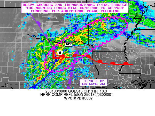
Mesoscale Precipitation Discussion 0007
NWS Weather Prediction Center College Park MD
421 AM EST Thu Jan 30 2025

Areas affected...Central to Northeast TX...Southeast OK...Western
and Central AR

Concerning...Heavy rainfall...Flash flooding likely

Valid 300920Z - 301520Z

SUMMARY...The threat for areas of flash flooding will continue
this morning from broken bands of heavy showers and thunderstorms
which will occasionally be capable of training over the same area.

DISCUSSION...The latest GOES-E IR satellite imagery along with
dual-pol radar continues to show broken areas of heavy shower and
thunderstorm activity impacting areas of central to northeast TX
through southeast OK and more recently into areas of western AR.

Strong warm air advection with the aid of a strengthening
south-southwest low-level jet of 30 to 50 kts continues to work in
tandem with modest instability, but rather strong moisture
convergence for sustainable convection. The flow aloft remains
rather divergent out ahead of a deeper layer low center slowly
ejecting east out into the southern High Plains, and this along
with a triple point low center over northern TX is further helping
to concentrate a corridor of rather strong forcing.

MUCAPE values remain generally around 1000 J/kg with PWs close to
1.5 inches, and this coupled with at least moderate shear should
continue to support some rainfall rates with the stronger storms
reaching as high as 1.5 inches/hour. This has been realized over
much of the DFW metroplex already where cell-training overnight
has yielded rainfall totals of as much as 2 to 5 inches.

As shortwave energy ejects off to the northeast across the
Arklatex region this morning, the overall axis of stronger warm
air advection and moisture transport should also translate off to
the northeast. This will help to maintain locally heavy showers
and thunderstorms along an axis that will still tend to linger
over northeast TX and southeast OK, but should move well
downstream into areas of western and central AR going through the
morning hours.

Given the locally heavy rainfall rates and periodic cell-training
concerns, additional rainfall totals of as much as 2 to 4 inches
are expected which is also supported by the 00Z HREF guidance and
recent HRRR runs. Some of these rains will be falling over areas
that have already seen locally heavy rainfall overnight, so
additional areas of flash flooding will generally be likely this
morning and especially over the more urbanized areas.

Orrison

ATTN...WFO...FWD...LZK...MEG...OUN...SHV...TSA...

ATTN...RFC...ABRFC...LMRFC...WGRFC...NWC...

LAT...LON   36009200 35839128 35319103 34489198 33439396
            32349544 31579663 31269764 31619826 32429817
            33229756 34439598 35469410 35849292
Download in GIS format: Shapefile
| KML
Last Updated: 421 AM EST Thu Jan 30 2025
