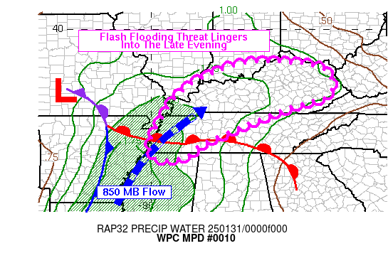
Mesoscale Precipitation Discussion 0010
NWS Weather Prediction Center College Park MD
1124 PM EST Thu Jan 11 2024

Areas affected...Central/Northern AR...Southern MO

Concerning...Heavy rainfall...Flash flooding possible

Valid 120423Z - 121023Z

SUMMARY...Areas of heavy showers and thunderstorms which will be
capable of occasionally training over the same area may result in
isolated instances of flash flooding. The main areas of concern
will be for central and northern AR into southern MO.

DISCUSSION...Strengthening warm air advection and moisture
transport out ahead of an amplifying upper-level trough and
associated cold front over the central and southern Plains will
continue to facilitate the development and expansion of heavy
shower and thunderstorm activity heading through the overnight
hours.

The area VWP data shows a convergent south-southwest low-level jet
on the order of 40 to 60+ kts nosing up across the Lower MS
Valley, and this coupled with a pool of at least modest elevated
instability with MUCAPE values of locally over 1000+ J/kg is
already leading to a fairly expansive area of convection across
west-central to northern AR, with some activity also developing
farther north over southern MO in the warm air advection regime.

Shear profiles are quite strong with as much as 50 to 60+ kts of
effective bulk shear in place across eastern OK and through much
of central and western AR, and the 3-hour MUCAPE differentials are
as much as +400 to +800 J/kg across much of this region which is
coinciding with the rapid convective cloud top cooling that has
been ensuing over the last couple of hours as stronger and more
organized updrafts materialize.

Heading through the overnight hours, heavy showers and
thunderstorms will tend to further expand in coverage off to the
northeast with areas of central to northern AR and southern MO
gradually getting into a more organized threat for heavy rainfall.
The convection may become aligned sufficiently parallel with the
deeper layer southwest flow to foster some occasional bands of
training convection, and this will yield at least some concern for
excessive rainfall totals.

The CIRA-LVT data is showing increasingly strong moisture
transport in the SFC-850mb layer and is reflective of the
strengthening low-level jet. This combined with the destabilizing
low-level environment should yield an increase in rainfall rates
that may reach upwards of 1.5 inches/hour with the stronger
convective cores. This is supported by the 00Z HREF and recent
runs of the experimental WoFS data.

Assuming at least some localized pockets of cell-training, some
rainfall totals by late tonight may reach as high 3 to 4 inches
which may result in some isolated instances of flash flooding,
with the urban areas at greatest risk.

Orrison

ATTN...WFO...LSX...LZK...MEG...PAH...SGF...SHV...TSA...

ATTN...RFC...ABRFC...LMRFC...MBRFC...NCRFC...NWC...

LAT...LON   38009141 37939019 37298934 36298964 35539023
            34319209 33999362 34339401 34889366 35289350
            35619380 35859446 36349467 37129430 37769283
Download in GIS format: Shapefile
| KML
Last Updated: 1124 PM EST Thu Jan 11 2024
