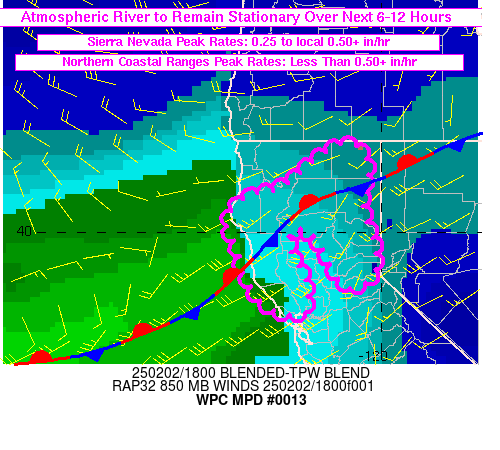
Mesoscale Precipitation Discussion 0013
NWS Weather Prediction Center College Park MD
236 PM EST Sun Feb 02 2025

Areas affected...northern California

Concerning...Heavy rainfall

Valid 021935Z - 030700Z

SUMMARY...Moderate to Heavy rain will continue over the northern
Sierra Nevada throughout the next 6-12 hours while a second round
of moderate to locally heavy rain develops for the northern
Coastal Ranges this evening. While locally higher totals will be
possible on an isolated basis, additional rainfall totals of 3 to
5 inches are expected for the northern Sierra Nevada into the
southern Cascades and an additional 1 to 2 inches for the northern
Coastal Ranges through 07Z.

DISCUSSION...Eastern Pacific view of total precipitable water (PW)
showed a relatively narrow axis of values greater than 1 inch
extending from near the triple point of an occluded cyclone 36N
138W (which showed up well in visible satellite imagery), ENE to
the northern CA coast. Gauge observations have shown peak hourly
rainfall totals in the 18Z hour of 0.1 to 0.2 inches for the
northern Coastal Ranges and 0.25 to locally in excess of 0.5 in/hr
for the northern Sierra Nevada. 24 hour totals near 9 inches have
been reported just east of Chico in the Sierra Nevada with up to
roughly 4 inches for the northern Coastal Ranges. Reports of
flooding thus far have been limited and primarily focused across
southern portions of the region on either side of I-80 in the
Sierra Nevada and between San Pablo Bay and Santa Rosa via local
storm reports.

Confluent mid-level flow between a mid-level low over southwestern
Canada and a low amplitude longwave trough centered near 145W
along with a ridge over the Baja Peninsula will keep zonal flow
focused from the northern CA and OR coastline, eastward into the
central U.S. through the overnight. At the surface, a shallow but
well-defined stationary front, co-located with the moisture axis,
will essentially remain in the same place over the next 6-12 hours
(slow northward drift), with low level winds varying within the
plume between 40-50 kt in the 850-700 mb layer. Some subtle
strengthening of 850 mb winds will be possible toward 00Z ahead of
the leading edge of a weak mid-level shortwave expected to near
the West Coast at 00Z, but IVT values are forecast to remain in
the 400-600 kg/m/s range through 06Z Monday across northern CA.

No significant changes to peak rainfall rates are expected for
northern CA through 06Z, but additional light to moderate rainfall
(perhaps locally heavy) is expected into the northern Coastal
Ranges later this evening with the approach of the offshore
mid-level impulse. Additional peak rainfall totals of 1-2 inches
for the Coastal Ranges and 3-5 inches for the northern Sierra
Nevada are likely over the next 12 hours but given rainfall rates
will remain somewhat modest, it is the long duration of this
rainfall event that will be noteworthy. At least through 06Z
tonight, additional flooding impacts are expected to remain
isolated with rainfall rates remaining under more critical
thresholds.

Otto

ATTN...WFO...EKA...MFR...MTR...REV...STO...

ATTN...RFC...CNRFC...NWC...

LAT...LON   41932111 41782055 41352037 41122043 40772058
            40382047 39872026 39282015 38942034 38772068
            38712095 38892118 39192143 39482163 39782182
            40032213 40082244 39972271 39512264 39282247
            38962222 38592215 38302216 38122234 38132269
            38222311 38502358 38832386 39182406 39592417
            40192451 40602421 40832377 40892338 40932300
            41122267 41302234 41712170
Download in GIS format: Shapefile
| KML
Last Updated: 236 PM EST Sun Feb 02 2025
