Mesoscale Precipitation Discussion 0015
NWS Weather Prediction Center College Park MD
913 PM EST Sun Feb 02 2025

Areas affected...Redding Area of Shasta County

Concerning...Heavy rainfall...Flash flooding possible

Valid 030212Z - 030700Z

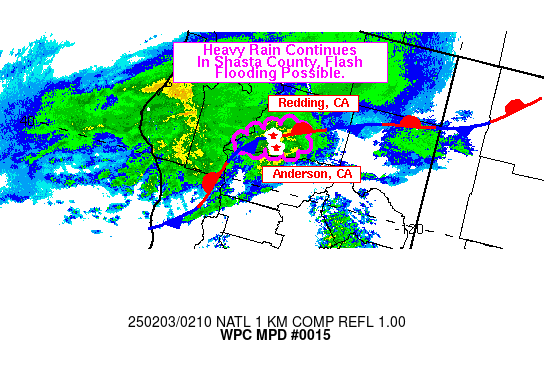
SUMMARY...Heavy rain associated with a convergence band over
Shasta County, CA will continue into tonight. Flash flooding will
be possible in addition to the ongoing areal flooding.

DISCUSSION...An impressive WSW-ENE convergence band that set up at
the head of the Sacramento Valley near Redding and Anderson, CA
continues to be the source of heavy rain this evening. A strong
southerly low level jet (LLJ) with winds of over 40 kts at 850 mb
continues along the Sacramento Valley, with surface stations south
of the band reporting winds as high as 20 kts south of the band.
The band had been nearly stationary over Anderson, CA or just
south of Redding, but trends have been for the band to crawl
northward with time. Guidance shows very little if any
instability, so this band is likely being forced by the strong
convergence in the area from the combination of the strong
southerly flow with the LLJ hitting a stationary front in that
same area, as well as localized upslope as the terrain of the
Sacramento Valley forms an arc, or upside down U, allowing for
southerly flow to become focused and converge in the Redding area.
Surface observations show there has been over 1.7 inches of rain
in the last 3 hours, and 2.5 inches of rain in the last 6.

HiRes guidance is in good agreement that the front and convergence
band will remain in place for at least the next several hours, if
not throughout the overnight (HRRR). With rates as high as an inch
per hour possible, expect continued areal flooding and possible
flash flooding in those areas where the convergence band interacts
with the terrain to focus the rain water into narrow streams,
creeks, and channels. Urban areas in and around Redding may also
locally increase the flash flooding threat.

Wegman

ATTN...WFO...EKA...STO...

ATTN...RFC...CNRFC...NWC...

LAT...LON   40792205 40692191 40492197 40422224 40402259
            40332288 40452290 40542276 40662255 40742235
Download in GIS format: Shapefile
| KML
Last Updated: 913 PM EST Sun Feb 02 2025
