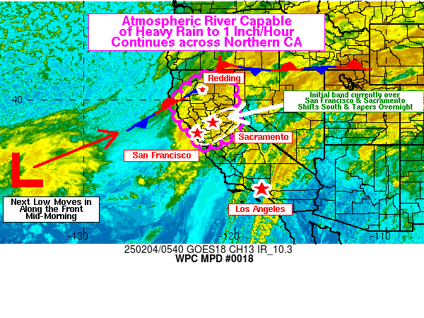
Mesoscale Precipitation Discussion 0018
NWS Weather Prediction Center College Park MD
1256 AM EST Tue Feb 04 2025

Areas affected...Central and Northern California

Concerning...Heavy rainfall

Valid 040600Z - 041800Z

SUMMARY...Heavy rain associated with the ongoing atmospheric river
may locally reach rates to 1 inch per hour with any convective
banding and heavier showers through mid-morning.

DISCUSSION...The primary AR has shifted into the Bay Area and
northeast through Sacramento this evening. For most areas, the
rain is generally light to moderate, producing 1/10 to 1/4 inch
per hour rates. The higher 1/4 inch per hour rates are largely on
the windward (southwest-facing) sides of the coastal ranges and
the Sierras. Onshore flow to 40 kt at 850 continues into the Bay
area. Upon moving inland the flow shifts to southerly as it tracks
along the foothills of the Sierras up the Sacramento Valley. This
low level jet has been the primary driver of the moisture
advection producing locally heavier rains in the form of
convergent bands and enhanced upslope rainfall activity over the
past few days. Since the LLJ isn't going anywhere, these local
"flare-ups" of heavier rain will continue through the overnight
and into Tuesday morning.

The band is expected to shift south of the I-80 corridor by around
10Z/2am PST based on all of the latest HiRes guidance. This will
leave the I-80 corridor from San Francisco through Sacramento in
off-and-on shower activity. The band will taper a bit as it stalls
out generally from a Monterey to Modesto line through the rest of
the overnight and into Tuesday morning. For far northern
California, the area is in a much needed break right now in most
areas, though very light rain and higher elevation snow continues
north of Redding. This break in the rain will continue through at
least sunrise as noted by the relative lack of higher cloud cover
off the coast of California on the graphic.

The next low is following swiftly behind this latest round.
Guidance has shifted significantly northward in the latest runs.
Thus, now expect another round of heavy rain to impact much of the
Sacramento Valley, including the hard-hit Redding area. This
heavier rain will arrive with the next low around 15Z/7am PST. IVT
values with the low will increase to around 750 kg/ms according to
CW3E interpolations of the GFS along the coast. The low will be
supported by a quickly-advancing zonal jet stream moving in from
the Pacific, so northern California will be in the left exit
region of that jet. The surface low will thus be supported by
favorable upper level dynamics. The heavy rain will be further
supported by the strengthening LLJ in the Sacramento Valley, which
will intensify in response to the approaching low and increasing
pressure gradient. It's likely that any 1 inch per hour rates with
any convergent bands will occur from mid-morning on due to the
additional moisture and advection.

Any resultant flooding from the heavy rain will likely be confined
to urban areas and flood-prone streams and creeks.

Wegman

ATTN...WFO...EKA...HNX...MFR...MTR...REV...STO...

ATTN...RFC...CNRFC...NWC...

LAT...LON   41642113 41392063 40972019 40202000 39102000
            38591974 38091969 37492045 37112124 36902191
            36992236 37492259 37812264 37972309 38182304
            38992387 39512390 39902398 39952396 40322377
            40672325 41062280 41582213
Download in GIS format: Shapefile
| KML
Last Updated: 1256 AM EST Tue Feb 04 2025
