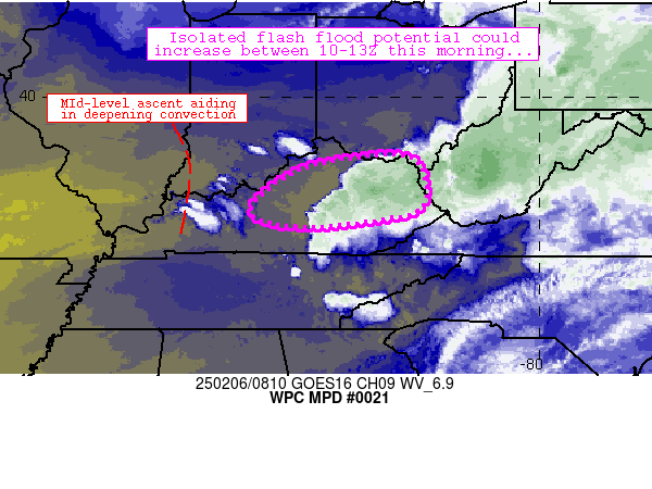
Mesoscale Precipitation Discussion 0021
NWS Weather Prediction Center College Park MD
322 AM EST Thu Feb 06 2025

Areas affected...northern/central Kentucky

Concerning...Heavy rainfall...Flash flooding possible

Valid 060821Z - 061321Z

Summary...At least minor/isolated flash flood potential should
continue through 13Z or so as upstream convection near the
Mississippi/Ohio River confluence migrates eastward through the
discussion area.

Discussion...Persistent, repeating convection along an axis from
near Lexington, KY to near Huntington, WV has produced several
areas of 1-1.75 inch rainfall totals over the past 3-6 hours
despite relatively quick movement.  The rainfall associated with
these storms has wet soils considerably across the region, with
most recently updated FFG thresholds lowering into the 0.25-0.75
inch/hr range and MRMS Flash responses suggestive of at least
isolated, minor flooding and runoff issues existing along that
corridor.

Convection upstream of this region is causing some concern that
perhaps another uptick in flash flood potential might occur
between 09-13Z.  This convection is expected to expand due to 1)
forcing for ascent aloft associated with mid-level vort maxima
across IL/IN, 2) fast low-level flow impinging on a warm front in
western KY, and 3) increasing MU/SBCAPE across the region.  CAMs
generally follow suit with this thinking, suggesting another round
of potential training convection entering the Lexington/Huntington
axis between 10-13Z with possible 0.25-0.75 inch/hr rain rates.

Should this potential materialize as forecast, isolated flash
flood potential can be expected especially in the 10-13Z timeframe.

Cook

ATTN...WFO...ILN...JKL...LMK...RLX...

ATTN...RFC...OHRFC...NWC...

LAT...LON   38728286 37988244 37468285 37208508 37498620
            38138567 38578468
Download in GIS format: Shapefile
| KML
Last Updated: 322 AM EST Thu Feb 06 2025
