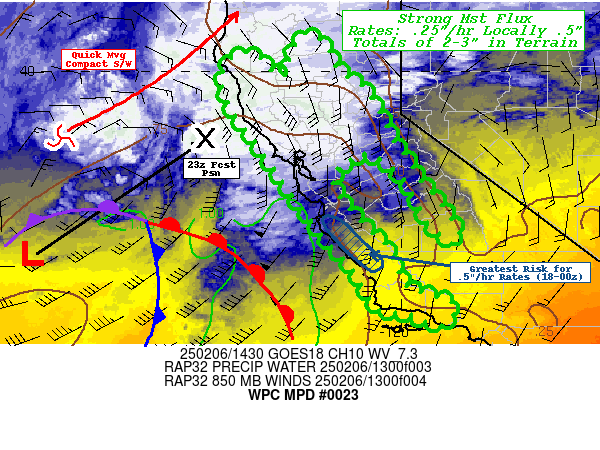
Mesoscale Precipitation Discussion 0023
NWS Weather Prediction Center College Park MD
943 AM EST Thu Feb 06 2025

Areas affected...Coastal Ranges, Sacramento Valley and Lower
Slopes of Sierra Nevada in California

Concerning...Heavy rainfall...Flash flooding possible

Valid 061500Z - 070300Z

SUMMARY...Compact, quick moving storm with anomalous moisture flux
to affect mainly coastal ranges at first but by late afternoon
transition to more convective localized convective showers with
training potential.  Given rates up to .5"/hr, locally 2-3" totals
are possible in favored orography.

DISCUSSION...GOES-W WV suite denotes a compact, increasingly
well-defined southern stream shortwave and associated surface low
near 38N and 128W lifting east-northeast with expanding baroclinic
shield downstream starting to cover much of northern California.
This wave/low will continue to strengthen and occlude further
throughout the day as northern upstream persistent upper-low
finally swings southeast and provides further DPVA and sharpens
the entrance region to the strengthen upper-level jet streak;
while steepening lapse rates with cold advection aloft (mainly
affecting northern CA later in the forecast period, after 00z),
prolonging the onshore flow and potential for locally heavy
rainfall.

RAP analysis/forecast shows strong warm advective pattern
approaching the central California coast with southerly 30kt 850mb
winds veering to 50-65kts in the 17-19z period.  The nose of the
LLJ is also accompanied by the core of a narrow warm
conveyor/moisture axis with 1-1.25" total PWats (though CIRA LPW
suggests this is mainly below 700mb) and trends continue to direct
it centered from Monterey Bay southward along the Santa Lucia
Range.  IVT values appear to be 600-700 kg/m/s and given
orthogonal ascent to the southern Santa Cruz and Santa Lucia
range, rates of .33-.5"/hr are likely to commence with the arrival
of the warm front around 17-18z and continue for 5-6hrs, with a
very slow southward drift of the core of the LLJ/moisture axis.
This magnitude of moisture flux is about 5 standard anomaly above
normal even in the wet season.  As such, localized totals of 2-3"+
are probable along the range. Later in the afternoon, the plume of
moisture sags south and rounds Cape Conception around 00z, winds
will slowly be diminishing to about 30kts at 850mb; there is some
more oblique (45-60 degrees) of orographic ascent in the
mid-levels, but southerly surface flow will not increase until
after the forecast period as the cold front rounds the bend.  So
at this time there is mixed signals to potential for sizable rates
over the fresh burn scars across the eastern Transverse Ranges, so
while not completely improbable for flash flooding/mudslides by
03z, we will be monitoring closely for potential for a targeted
MPD if conditions increase/warrant it later into this
evening/overnight.

Meanwhile, further north the western branch of the TROWAL will
provide ample moisture flux wrapping north of over the
surface-850mb low to feed surface upslope forcing to allow for
moderate rainfall with .25-.33" rates along the coastal ranges
north of the San Francisco Bay; which should slowly expand
eastward through into the lower slopes of the Trinity to northern
Sierra Nevada Ranges.   As the upper-level northern stream DPVA
swings southeast, providing some cooling aloft and steepening
lapse rates, it will also help to sharpen the
deformation/convergence zone across NW CA as the surface low
transitions from coastal to northern central Valley from 23-01z.
An uptick in convective activity with slight reduction in forward
speed may result in spotty .33-.5"/hr rates across the
Redwood/Lost Coast resulting in localized totals of 2-3" by 03z as
well, this should remain more of a heavy rainfall risk as the
older burn scars are less susceptible, but an isolated
creek/stream with quick rise is not completely out of the picture
given soil conditions remain above average in the 80-95
percentiles even for this time of year given recent rainfall.

Bottom-line, this quick hitting/strong moisture flux is highly
anomalous even in the wet season but the overall rates and totals
still generally remain below flash flooding concerns and will hold
with a 'heavy rainfall' tag at this time; however will convective
trends closely for any potential targeted MPDs and flash flooding
conditions.

Gallina

ATTN...WFO...EKA...HNX...LOX...MTR...STO...

ATTN...RFC...CNRFC...NWC...

LAT...LON   40862210 40712184 40432167 40082152 39602087
            39172059 38832038 38522027 38141999 37601966
            37271940 36881906 36511880 36191865 35951876
            36131904 36361928 36671951 37201977 37752022
            38092079 37922118 37852141 37492161 37032143
            36472092 35972040 35722025 34981988 34761927
            34551873 34071906 34331984 34422053 34812083
            35452118 36102182 37532286 38292338 39092396
            39782422 40382392 40422342 40172319 39972297
            39912271 40212264 40582251 40842237
Download in GIS format: Shapefile
| KML
Last Updated: 943 AM EST Thu Feb 06 2025
