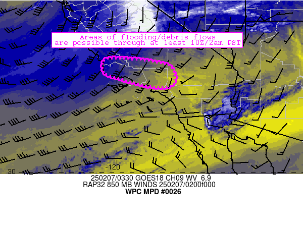
Mesoscale Precipitation Discussion 0026
NWS Weather Prediction Center College Park MD
1048 PM EST Thu Feb 06 2025

Areas affected...portions of southern California

Concerning...Heavy rainfall...Flash flooding possible

Valid 070348Z - 070948Z

Summary...Increasing onshore flow is interacting with the
Transverse Ranges in southern California to produce scattered
showers and locally heavy rainfall.  Rainfall totals of 0.25-1
inch are possible through 10Z/2am and beyond.  Excessive runoff
and debris flows are a distinct possibility - especially near
sensitive areas of variable terrain and near burn scars.

Discussion...Over the next several hours, a strong low-level
cyclone (currently centered near Eureka) will migrate
northeastward toward Oregon.  As this occurs, strong southwesterly
low-level flow will increase across portions of southern
California especially near terrain-favored coastal ranges.  Moist
air (characterized by 1-1.1 inch PW values) will accompany the
increasing flow and become forced over the Transverse Ranges,
resulting in areas of orographically enhanced moderate to heavy
rainfall.  This process is already underway, with spots of 0.2-0.4
inch/hr rain rates already observed west of Los Angeles in the
past hour very near Malibu and Castaic.  These trends are expected
to continue, and a roughly 6-12 hour window of heavier rainfall
potential will exist across the discussion area continuing into
the overnight hours (perhaps through 12Z-15Z Friday).

These areas of heavy rainfall will occur in areas of sensitivity
from both terrain and burn scars from recent fires across the
region.  As a result, areas of flooding and debris flows are
possible.  Rainfall totals of 0.25-1 inch are probable through
10Z, with locally higher amounts (exceeding 1.5 inches) possible
in terrain-favored areas.

Cook

ATTN...WFO...HNX...LOX...SGX...VEF...

ATTN...RFC...CNRFC...NWC...

LAT...LON   35242052 35241936 35121841 34921756 34291731
            33971765 34001857 34512041 34842065
Download in GIS format: Shapefile
| KML
Last Updated: 1048 PM EST Thu Feb 06 2025
