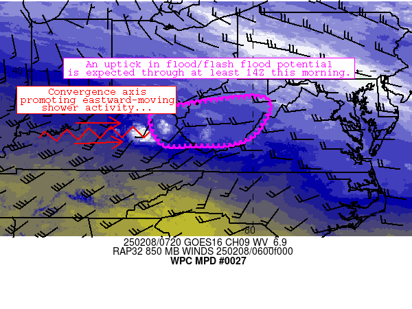
Mesoscale Precipitation Discussion 0027
NWS Weather Prediction Center College Park MD
240 AM EST Sat Feb 08 2025

Areas affected...much of West Virginia and a small part of eastern
Kentucky

Concerning...Heavy rainfall...Flash flooding possible

Valid 080740Z - 081340Z

Summary...At least minor/isolated runoff issues could develop in
the next few hours as moderate rain moves in from central/northern
Kentucky through 14Z.

Discussion...Strong convergence on the nose of a 40-kt low-level
jet over western Kentucky has aided in development of moderate
rainfall generally along an axis from near Louisville to near the
WV/KY border near Pikeville.  Within this axis, the persistence of
rainfall has allowed for MRMS-estimated areas of 0.10-0.30 inch/hr
rain rates to materialize.  The axis was also parallel to robust
westerly flow aloft (supporting persistence), and recent radar
mosaic imagery indicates upstream shower activity near the MS/OH
River confluence poised to move through areas currently affected
by moderate rainfall.  The net result of this pattern is a fairly
prolonged period of light to moderate rainfall eventually
extending into West Virginia, with 0.75-1.25 inch rainfall totals
expected through 14Z across the discussion area.

Despite modest rain rates, soils are wet across the area from
recent rainfall and FFG thresholds are 1) ~0.25 inch/hr and 2)
less than 1 inch/3-hr across parts of the region (especially in
hillier terrain in eastern WV).  These thresholds and recent flash
flood events suggest that ground conditions are extremely
sensitive.  The moderate rainfall moving in from Kentucky should
persist for several hours, resulting in at least isolated
instances of excessive runoff/flooding.  The uptick in flood risk
should persist in the 0830Z-1400Z timeframe and beyond as
low-level convergence strengthens across the area through the day.

Cook

ATTN...WFO...ILN...JKL...LWX...PBZ...RLX...RNK...

ATTN...RFC...MARFC...OHRFC...NWC...

LAT...LON   39108015 39037954 38687946 38157973 37708021
            37518090 37498204 37568309 38528343 38888208
            38988118
Download in GIS format: Shapefile
| KML
Last Updated: 240 AM EST Sat Feb 08 2025
