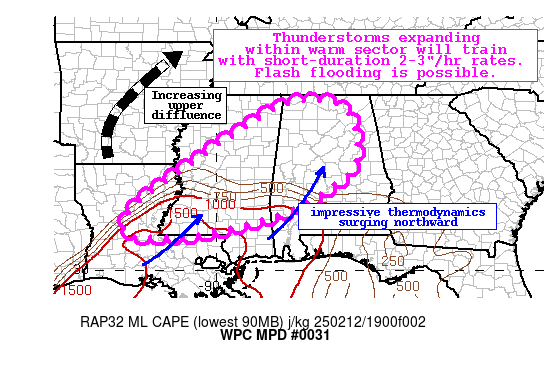
Mesoscale Precipitation Discussion 0031...Corrected
NWS Weather Prediction Center College Park MD
331 PM EST Wed Feb 12 2025

Corrected for updated graphic

Areas affected...Lower Mississippi Valley through Northern Alabama

Concerning...Heavy rainfall...Flash flooding possible

Valid 122024Z - 130215Z

Summary...Showers and thunderstorms rapidly blossoming within a
warm sector will expand in coverage and intensify through the
afternoon. These thunderstorms will lift northward and then train
SW to NE ahead of a cold front, with rainfall rates as much as
2-3"/hr. This could lead to instances of flash flooding.

Discussion...The regional radar mosaic across the Gulf Coast this
afternoon depicts rapidly expanding and intensifying thunderstorms
along and just south of a warm front from LA to the FL Panhandle.
This convection is expanding within a pronounced warm sector
characterized by favorable instability (MLCAPE 1000-2000 J/kg) and
elevated PWs (1.6 to 1.8 inches) according to the SPC
mesoanalysis. Additionally, recent VWPs from the region indicate
modest low-level veering but with strong inflow, supporting large
updrafts capable of producing intense rainfall rates. This is
being analyzed by recent MRMS 15-min rainfall as high as 0.75"
(3"/hr rates), resulting in rising CREST unit streamflow values
across parts of LA and MS. Upstream of this fresh convection, a
wave of low pressure and attendant cold front are analyzed by WPC
crossing from TX into LA, along which additional thunderstorms are
occurring with current FFWs.

As the afternoon progresses into the evening, the environment
should become increasingly unstable as the plume of 1000-2000 J/kg
MLCAPE surges as far north as Birmingham, concurrent with elevated
PWs being drawn northward. This plume of robust thermodynamics
will be advected on 850mb inflow that is progged to reach 50+ kts,
resulting in 850-700mb moisture flux that may exceed 5 sigma
according to the SREF. Additionally, increasing synoptic lift
within the RRQ of an intensifying jet streak will support an
expansion of convection into the evening, with thunderstorms
likely aligning along or just ahead of the convergence axis of the
approaching cold front as it squeezes the warm sector. This
alignment will rapidly enhance the flash flood risk, as training
of cells along the boundary will offset the limiting storm speed
of 40-60kts.

The HREF suggests that coverage of rainfall rates exceeding 1"/hr
will expand, and the HRRR 15-min progs suggest rainfall intensity
may produce 0.75 to 1 inch of rain in as little as 15 minutes.
These rates themselves could cause instances of flash flooding,
but where training occurs, more than 3" of rain is possible,
enhancing the flash flood risk. The most likely locations for any
flash flooding will be across urban areas as soil moisture in
southern LA, MS, AL is drier than normal according to NASA SPoRT.
However, training of these intense rain rates could quickly
overwhelm even the drier soils, so flash flood instances are
possible anywhere across the discussion area into this evening.


Weiss

ATTN...WFO...BMX...HUN...JAN...LCH...LIX...MEG...MOB...SHV...

ATTN...RFC...LMRFC...SERFC...NWC...

LAT...LON   34828712 34538627 33658599 32878613 32308688
            31708793 31268939 30989077 30979206 30969237
            31009261 31569255 32349167 34568837
Download in GIS format: Shapefile
| KML
Last Updated: 331 PM EST Wed Feb 12 2025
