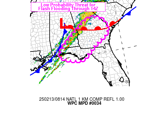
Mesoscale Precipitation Discussion 0034
NWS Weather Prediction Center College Park MD
317 AM EST Thu Feb 13 2025

Areas affected...FL Panhandle into southeastern AL and central GA

Concerning...Heavy rainfall...Flash flooding possible

Valid 130815Z - 131345Z

SUMMARY...A low probability threat for flash flooding due to
training will exist from the FL Panhandle into southeastern AL and
central GA through ~13Z. The threat will carry the potential for
rainfall rates in the 1-2 in/hr range within any areas of training.

DISCUSSION...Radar imagery at 08Z showed that a SW to NE oriented
axis of thunderstorms extended from the western FL Panhandle into
north-central GA. These thunderstorms were located out ahead of a
cold front and trends over the past few hours have shown a
weakening of the portion of the line over southwestern AL in favor
of strengthening of a new line out ahead, which was currently
crossing the western FL Panhandle. Recent infrared satellite/radar
trends through 08Z showed yet another line beginning to organize
about ahead of the existing convective axis, ~85 miles south of
Mobile Bay.

The environment within the warm sector was characterized by 500 to
1500 J/kg MLCAPE from the warm frontal position along the AL/GA
border to just south of the Gulf Coast along the FL Panhandle.
Flash flood guidance was lowest to the north (2-3 inches in 3
hours) and highest in western FL (4+ inches in 3 hours). The
greatest potential for high rainfall rates, near or even in excess
of 2 in/hr, will exist within the better instability across
southern locations.

Water vapor imagery showed a longwave trough over the central U.S.
advancing east, but with the base of the trough lifting north,
from OK to the MS Valley. This deamplification along the southern
end of the upper trough favors a gradual weakening trend of 850 mb
wind magnitude and of convective intensity over the AL/GA/FL
tri-state region. However, lingering instability and sufficient
low level moisture transport could allow for training if the
convective axis to the south continues to expand north and meets
with the ongoing northern portion advancing to the east at a
somewhat faster pace. While the general movement should be a
progressive eastward movement at 25-30 kt, There is a low end
chance that alignment of the heavy rain axis/axes will allow for a
brief period of training, which could contain rainfall rates of
1-2 in/hr, and local 2-3 inches of rain over a 2 to 3 hour window.
Localized flash flooding could result, but again, this threat
appears to be fairly low and recent CAM guidance does not support
much in the way of a flash flood threat over the next 3-5 hours.

Otto

ATTN...WFO...BMX...CAE...CHS...FFC...JAX...MOB...TAE...

ATTN...RFC...SERFC...NWC...

LAT...LON   33618302 33498228 33078167 32528146 31768171
            30898320 30198408 29568500 30128734 31088690
            32538513 33028448 33508380
Download in GIS format: Shapefile
| KML
Last Updated: 317 AM EST Thu Feb 13 2025
