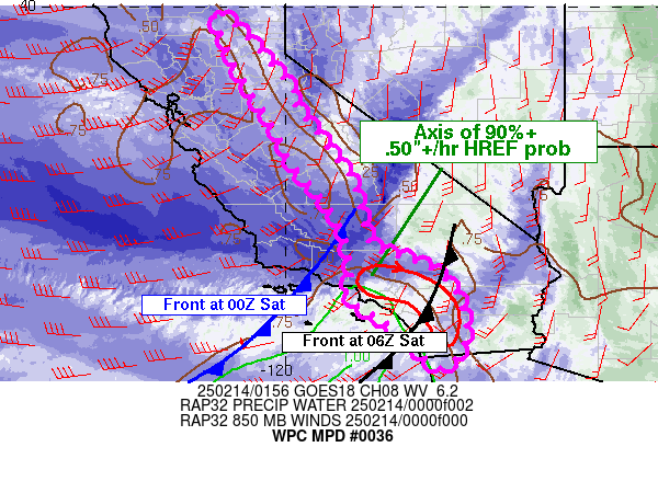
Mesoscale Precipitation Discussion 0036
NWS Weather Prediction Center College Park MD
916 PM EST Thu Feb 13 2025

Areas affected...Coastal Southern California...Foothills of the
SIerra

Concerning...Heavy rainfall...Flash flooding likely

Valid 140200Z - 141200Z

SUMMARY...The ongoing Atmospheric River event will continue into
the early hours of Saturday, with the threat of .50-.75"+ hourly
rainfall rates across portions of Southern California and into the
western upslope of the Sierra.  Flash flooding will remain likely
across Southern California, especially across recent burn scar
areas, and possible in the foothills of the Sierra.  The flash
flooding threat will be diminishing from west to east across
Southern California after 0200 UTC as a cold front moves steadily
east, but should perist to near 1200 UTC in the Sierra Foothills.

DISCUSSION...The latest GOES-W satellite imagery shows the broad
mid to upper level trof along the west coast pushing steadily
inland.  An axis of anomalous PW values..2 to 2.5+ standard
deviations above the mean, and 850-700 mb moisture flux anomalies
of 3 to 5+ standard deviations above the mean, will continue on
the southeast side of this upper trof, along and ahead of the
associated cold front pushing steadily eastward across Southern
California this evening.   Surface analysis at 0000 UTC indicates
this front having pushed to the southeast of Santa Barbara and
extending eastward just south of Sandburg and Edwards AFB.
There is good consensus in the latest hi res guidance on the
timing of the primary heavy rain areas in the vicinity of this
front pushing across Southern California this evening.  HREF
neighborhood probabilities are high, 90%+, for hourly rain totals
of .50"+/hr along and ahead of the front, but drop to generally
less than 25% for 1"+/hr, reflective of the progressive nature of
this front.  This progression will lead to a sharp cutoff in the
flash flood threat as the front passes.  However, until this
occurs, flash flooding will remain likely across Southern
California, especially over recent burn scar regions.

..Foothills of the Sierra Nevada...
While the primary anomalous PW axis will remain across Southern
California this evening, persistent west southwesterly low level
upslope flow level will continue to impact the foothills of the
Sierra into early Saturday.  HREF neighborhood probabilities for
.50"+/hr rainfall amounts are not as high or continuous as areas
across Southern California. but do depict potential for localized
heavy amounts and the potential for flash flooding issues.
Simulated hi res radars do show potential for cells to be much
slower moving and train in the upslope regions of the Sierra.  In
areas of training, additional hourly amounts of .50-.75"+ and
additional totals of 2-3" are possible through early Saturday
morning.


Oravec

ATTN...WFO...HNX...LOX...PSR...SGX...STO...VEF...

ATTN...RFC...CNRFC...NWC...

LAT...LON   39932145 39242074 38191983 38101991 37181925
            36221856 35051825 34711787 34711774 34451696
            34351684 33951639 32951616 32321669 33011746
            33041754 33101769 33441803 33491825 33951871
            34411857 35511890 36741990 37352017 38572095
            39722147
Download in GIS format: Shapefile
| KML
Last Updated: 916 PM EST Thu Feb 13 2025
