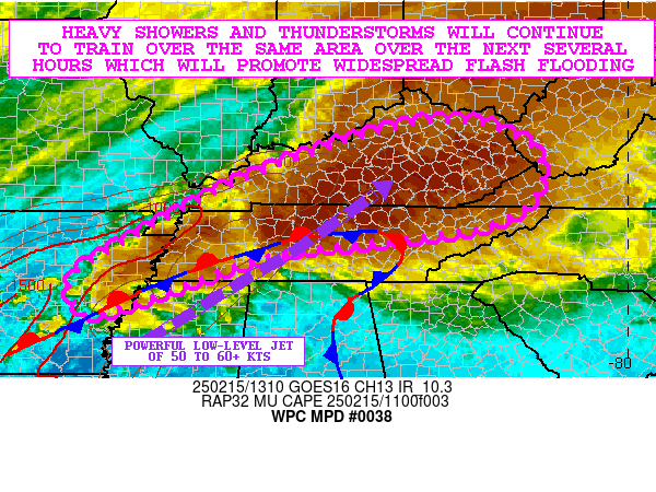
Mesoscale Precipitation Discussion 0038
NWS Weather Prediction Center College Park MD
1156 AM EST Sat Jan 27 2024

Areas affected...Northern GA...Upstate SC...Western NC...

Concerning...Heavy rainfall...Flash flooding possible

Valid 271700Z - 272300Z

SUMMARY...Enhanced Moisture flux into upslope portion of Southern
Appalachians with strong WAA.  Embedded thunderstorms to develop &
potentially repeat with 1-1.5"/hr rates and spots of 2-3" totals
across saturated/dormant soils.  Localized flash flooding is
possible through evening.

DISCUSSION...GOES-E depicts a mature deep layer cyclone across the
Lower Mississippi Valley with warm conveyor belt/pre-frontal
trough crossing the central Gulf Coast into the Cumberland
Plateau, providing deep moisture flux along increasing low level
flow with 20-25kts of southerly flow across GA increasing to near
40kts back along/west of the warm conveyor belt.

At the surface, a stationary front remains well defined across
northern AL/GA angling between I-85 and I-20 across SC; solid
east-northeasterly and northeasterly flow continue to dam in
slightly cooler but still moist air across much of the area of
concern.  However, surface and VWP across central GA, denote that
strengthening WAA and in steepening the isentropic gradient across
N GA/SC, convergence has sparked a few shallow convective cells
scattered within the region.  Upper-level diffluence as the 3H jet
turns north into the Ohio River Valley, will support further
evacuation through the afternoon into evening hours broadening
light to moderate showers in the upslope regions of NE GA, SC and
W NC, with those continued embedded cells capable of quick .25-.5"
totals, setting the stage for saturating the upper few centimeters
of an already saturated 0-40cm layer.  NASA SPoRT LIS ratios are
well above normal into the 90-98th percentiles and values of
80-90%, particularly across the highest slopes of NC but also
along a swath from near Columbus to Athens, GA which may be fully
saturated.  As such, FFG values which are 1-2"/hr and 1.5-2.5"/3hr
may be a bit high and and may have increased runoff potential for
any showers.

Of greatest concerns, a bit of filtered insolation within the warm
advective regime along/ahead of the pre-frontal trough may allow
for some steepened lapse rates and MUCAPE values of 500-750 J/kg
by late afternoon, especially further east into E GA/SC.  Total
PWAT values start reaching 1.5" on that 30-40kt LL flow supporting
strong flux into any cells that develop.  As such, a stronger
convective signal is noted in the 12z Hi-Res CAMs and recent HRRR
runs across the area of concern, even off the upslope regions
closer toward the fall-line in GA/SC, but HREF signals suggest
1"/hr from 30-50% and 2"/3hrs up to 20% about 21-00z across NE GA
into SC, providing some confidence in efficient rainfall
production.  Combined with prolonged moderate rainfall in
NC/Upstate SC, totals of 1-3" may be scattered across the area of
concern through 00z with localized flash flooding considered
possible.

Gallina

ATTN...WFO...CAE...FFC...GSP...MRX...

ATTN...RFC...LMRFC...SERFC...NWC...

LAT...LON   35858205 35748094 34788062 33798181 33158318
            33288431 33678460 34308473 35018427 35678331
Download in GIS format: Shapefile
| KML
Last Updated: 1156 AM EST Sat Jan 27 2024
