Mesoscale Precipitation Discussion 0040
NWS Weather Prediction Center College Park MD
155 PM EST Sat Feb 15 2025

Areas affected...Lower MS Valley into the Mid-South and OH Valley

Concerning...Heavy rainfall...Flash flooding likely

Valid 151855Z - 160055Z

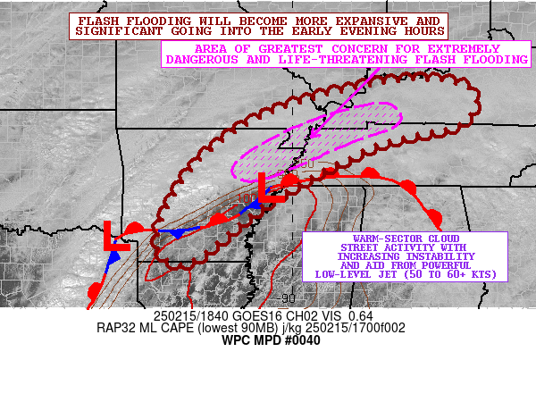
SUMMARY...Flash flooding will become more expansive and
significant going into the early evening hours as heavy showers
and thunderstorms organize and train over the same area. Some of
the flash flooding is expected to be extremely dangerous and
life-threatening.

DISCUSSION...Strong shortwave energy ejecting east out across the
southern Plains will be encroaching on the Lower MS Valley this
afternoon and will be interacting with a moist and increasingly
unstable airmass which coupled with strengthening shear profiles
will set the stage for expanding clusters of strong to severe
thunderstorms. This is likely to include a combination of
multicell and supercell convection which will be embedded within
an environment conducive for yielding very heavy rainfall rates.

GOES-E visible satellite imagery shows a notable increase in cloud
street activity across LA/MS and through central and southern AR
which is indicative of an increasingly unstable boundary layer.
Diurnal heating via solar insolation has allowed for MLCAPE values
to increase to 1000 to 1500 J/kg, and these values will continue
to increase over the next few hours. A quasi-stationary front is
draped from the Arklatex northeastward into northern MS and far
southwest TN with multiple waves of low pressure noted along it.
Meanwhile, a powerful southwest low-level jet is in place reaching
upwards of 50 to 60+ kts and this is yielding very strong moisture
transport from the Gulf of America up across the broader Lower MS
Valley and Mid-South region with PWs that have now increased to
1.3 to 1.5 inches.

As thunderstorms continue to develop and organize over the next
several hours, there will be rainfall rates capable of reaching
1.5 to 2 inches/hour with the stronger cells. Cell-merger and
cell-training concerns will increase by later this afternoon and
this evening with potentially some QLCS-related training of storms
possible in the 21Z to 00Z time frame from south-central to
northeast AR into the MO Bootheel, northwest TN and far southwest
KY. This is favored by a consensus of the 12Z HREF and the 16Z to
18Z runs of the experimental WoFS guidance which shows a
combination of multicell, supercell and QLCS-driven convection
heading into the evening hours.

Additional rainfall amounts of as much as 3 to 6 inches are
expected within the corridors of greatest cell-training which
currently is being most favored across northeast AR into the MO
Bootheel, northwest TN and far southwest KY going through 00Z.
Given that some of these areas already have flash flooding
ongoing, the additional rains are likely to foster extremely
dangerous and life-threatening flash flooding conditions by this
evening, with Flash Flood Emergency level impacts possible. As
conditions evolve this evening, additional MPDs will be issued to
address this high-impact event.

Orrison

ATTN...WFO...LMK...LZK...MEG...OHX...PAH...SGF...SHV...

ATTN...RFC...ABRFC...LMRFC...OHRFC...NWC...

LAT...LON   37798645 37448527 36658564 36088783 34629061
            33119252 33099332 33889348 35589251 36809080
            37528852
Download in GIS format: Shapefile
| KML
Last Updated: 155 PM EST Sat Feb 15 2025
