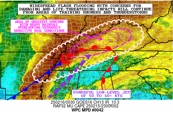
Mesoscale Precipitation Discussion 0042
NWS Weather Prediction Center College Park MD
745 PM EST Sat Feb 15 2025

Areas affected...Lower MS Valley into the Mid-South and OH Valley

Concerning...Heavy rainfall...Flash flooding likely

Valid 160045Z - 160645Z

SUMMARY...Widespread flash flooding with potentially damaging and
life-threatening impacts will continue as showers and
thunderstorms continue to train locally over the same area and
focus heavy rainfall totals.

DISCUSSION...The latest GOES-E IR satellite imagery along with
dual-pol radar shows widespread and well-organized showers and
thunderstorms impacting much of the Lower MS Valley with a
northeastward extension up across portions of the Mid-South and
the OH Valley. Strong shortwave energy is crossing the Arklatex
and will be rapidly lifting northeastward into the OH Valley
overnight. As it does so, the energy will be interacting with a
moist and moderately buoyant airmass continuing to surge
northeastward from the Lower MS Valley.

This airmass is characterized by MUCAPE values of as much as 1000
to 1500 J/kg and PWs approaching 1.5 inches which is also being
aided by the persistence of a powerful 50 to 60+ kt southwest
low-level jet. Radar imagery shows a QLCS currently evolving from
eastern AR up across western TN and western KY with some embedded
supercell convection. The better thermodynamics are situated from
southeast AR through northern MS and into western TN and this
should provide convective sustenance through the remainder of the
evening hours as the overall QLCS activity advances off to the
east.

While the southern flank of the overall convective footprint this
evening should become increasingly progressive as a cold front
arrives from the west, there will still be notable concerns for
training showers and thunderstorms for several more hours farther
off to the northeast in close vicinity of a warm front lifting
north through the OH Valley.

Rainfall rates with the stronger storms over the next several
hours will still be capable of reaching 1.5 to 2 inches/hour with
the strongest of cells. Additional rainfall amounts going through
06Z may reach as high as 2 to 4 inches with isolated heavier
amounts not out of the question.

Many areas have already received 2 to 4 inches of rain since early
this morning, and the extremely sensitive ground conditions with
saturated soils and ongoing widespread areas of flash flooding
coupled with the additional rainfall, will pose concerns for
potentially Flash Flood Emergency level impacts with damaging and
life-threatening conditions. This situation will continue to be
closely monitored.

Orrison

ATTN...WFO...ILN...JKL...LMK...LZK...MEG...MRX...OHX...PAH...
RLX...

ATTN...RFC...LMRFC...OHRFC...NWC...

LAT...LON   38918407 38398319 37498313 36788408 36358516
            35508719 34558970 34249121 34669174 35549119
            36728984 37428858 38068736 38868545
Download in GIS format: Shapefile
| KML
Last Updated: 745 PM EST Sat Feb 15 2025
