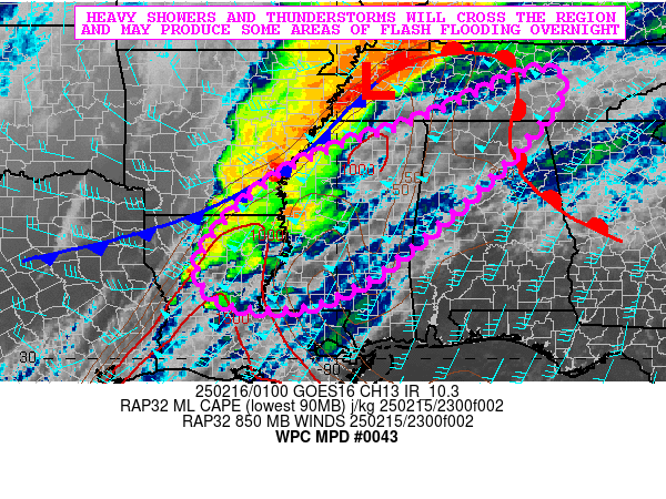
Mesoscale Precipitation Discussion 0043
NWS Weather Prediction Center College Park MD
820 PM EST Sat Feb 15 2025

Areas affected...Northern LA...Central and Northern MS...Western
and Northern AL...Middle TN

Concerning...Heavy rainfall...Flash flooding possible

Valid 160120Z - 160720Z

SUMMARY...Heavy showers and thunderstorms will be sweeping across
the region over the next several hours which may produce some
areas of flash flooding, with especially the more urbanized
locations at risk for potential runoff problems.

DISCUSSION...Radar and satellite imagery shows an evolving QLCS
crossing through areas of eastern AR through western TN, with more
broken clusters of organized convection including a few supercells
down across areas of northern LA which is beginning to move into
areas of western MS.

The airmass downstream of the current convection is moist and
moderately buoyant with MLCAPE values of 1000 to 1500 J/kg locally
and PWs of near 1.5 inches. However, a substantial amount of shear
remains in place ahead of the strong shortwave and attendant
frontal system crossing the Lower MS Valley. A very strong
low-level jet of 50 to 60+ kts remains a key player in driving
enhanced moisture/instability transport and this will sustain the
convective threat well into the overnight hours as a cold front
approaches and eventually crosses the region.

Rainfall rates associated with the QLCS and more discrete
supercell activity over the next several hours will likely reach
as high as 1.5 to 2 inches/hour, and there may be at least some
occasional cell-merger and cell-training activity that will
support some locally excessive rainfall totals that may reach 2 to
4 inches.

NASA SPoRT data shows antecedent soil conditions on the moist side
across much of the region given the heavy rainfall that occurred a
few days ago. This coupled with the locally heavy convective rains
over the next several hours may pose at least some concern for
areas of flash flooding. However, generally the more urbanized
locations will be at greatest risk for runoff problems and impacts
heading into the overnight hours.

Orrison

ATTN...WFO...BMX...HUN...JAN...LCH...LIX...LZK...MEG...MRX...
OHX...SHV...

ATTN...RFC...LMRFC...OHRFC...SERFC...NWC...

LAT...LON   36018588 35688528 34408623 32918779 31708932
            31109076 31149210 31389265 31909290 32679249
            33559157 34289031 35008825
Download in GIS format: Shapefile
| KML
Last Updated: 820 PM EST Sat Feb 15 2025
