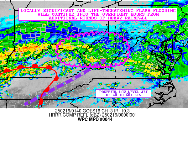
Mesoscale Precipitation Discussion 0044
NWS Weather Prediction Center College Park MD
900 PM EST Sat Feb 15 2025

Areas affected...Portions of the OH Valley and Central
Appalachians

Concerning...Heavy rainfall...Flash flooding likely

Valid 160200Z - 160800Z

SUMMARY...Locally significant and life-threatening flash flooding
will continue into the overnight hours with additional Flash Flood
Emergency level impacts possible from additional rounds of heavy
rainfall, with the central Appalachians continuing to see the
greatest risk of this.

DISCUSSION...The latest radar imagery continues to show an
expansive area of heavy rainfall impacting areas of mainly
north-central to northeast KY through central WV and down into
areas of south-central VA. The activity continues to be associated
with strong warm air advection which is being aided by a powerful
southwest low-level jet of 40 to 60+ kts surging up through the
OH/TN Valley region and into the central Appalachians.

Very strong transport continues as a result which coupled with
enhanced isentropic ascent and frontogenetical forcing continue to
yield heavy rainfall rates generally in the 0.25" to 0.50"/hour
range with some occasionally heavier rates where some embedded
elevated convective elements focus. Some very modest instability
with MUCAPE values of as much as 100 to 250 J/kg is noted over the
region and this continues to favor at least some transient pockets
of convection.

A warm front continues to gradually lift north into the OH Valley
and central Appalachians and this is allowing for the overall
heavy rainfall shield to gain latitude. Going into the overnight
hours, rainfall rates should still be capable of reaching a
0.50+"/hour locally and especially with the aforementioned pockets
of elevated convection. Additional rains of as much as 1 to 2
inches will be possible over the next 6 hours, with areas closer
to the OH River involving northeast KY and southern OH seeing
potentially 2 to 3 inches given heavier rainfall approaching from
western KY including some stronger pockets of even stronger
convection.

Given the additional rainfall and ongoing widespread focus of
areal flooding and flash flooding, significant and
life-threatening flash flooding is likely to continue with
additional potential for Flash Flood Emergency level impacts. This
will especially be the case over portions of the central
Appalachians where there have already been a total of 4 Flash
Flood Emergencies issued since early this afternoon.
Orrison

ATTN...WFO...ILN...JKL...LMK...LWX...PBZ...RLX...RNK...

ATTN...RFC...MARFC...OHRFC...NWC...

LAT...LON   39878106 39677973 39037917 38167920 37658001
            37598196 37648310 37888390 38408422 39038417
            39528328 39768232
Download in GIS format: Shapefile
| KML
Last Updated: 901 PM EST Sat Feb 15 2025
