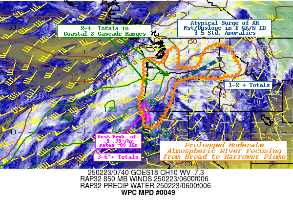
Mesoscale Precipitation Discussion 0049
NWS Weather Prediction Center College Park MD
253 AM EST Sun Feb 23 2025

Areas affected...Coastal and Cascade Ranges of S WA, OR & Far
Northwest CA & E WA/SE OR/N ID...

Concerning...Heavy rainfall

Valid 230800Z - 231800Z

SUMMARY...Prolonged AR continues but very broad plume of moisture
will start to focus ahead of next stronger cyclone/frontal push
toward 18z.  Deep moisture surges through the Columbia Plateau
into E WA/N ID prepping the soils/increasing run-off ahead of next
surge.

DISCUSSION...GOES-W WV suite shows broad cirrus canopy associated
with polar jet streak and deep atmospheric river extending from
the eastern Pacific across W WA into S British Columbia into the
entrance of the core jet streak that is about 150-160kts.  The
weakening/initial low level cyclone has occluded northward into
the central BC coastal region with the front extending southward
into/near the Cascade Range, while the warm front extends through
the Columbia River Valley.  CIRA LPW, particularly the sfc-850mb
layer bares this evolution out very well with the cold front
starting to sag/stall SW to NE just across the W WA angling back
toward the next approaching stronger wave out near 150W.   The
plume remains very broad/wide from the W WA coast to the
Lost/Redwood coast of northwest California with a solid slug of
850-500mb centered on the NW Oregon coast extending back toward
37-38N and 140W; both layers showing associated moisture flux
values running well into 99th percentile for the 20 year record.
As such, 1.25" TPW values intersect much of the coastline with
weakly confluent 850-700mb flow angled from the SW about 30
degrees off perpendicular, but given the depth has washed over the
coastal range to to the Cascades.   Still, within a broad ascent
pattern in the exiting right entrance pattern provides a
continuation of moderate rainfall rates of .25-.3"/hr, slowly
reducing from north to south across the WA Cascades through the
early morning (but remaining solid further south across OR).  This
should result in 2-4" totals across the coastal and Cascade ranges
of Oregon to 18z; with 1.5-2.5" across WA early through 15z.

...Eastern Washington/N Idaho...
As noted above, the broad plume is broad and deep enough to wash
over the coastal range and has begun to fill the Columbia river
Valley into the Plateau region.  IVT values of 300-400 kg/m/s will
increase to near 500-600 kg/m/s along 30-45kts of gap flow through
the Plateau into the foothills and eventually higher terrain of SW
WA/NE OR and then toward the Clearwater Range by 12z.  Total PWat
values are starting to increase above .75" which would place 90+th
percentile moisture for the date at OTX and GFS/ECMWF flux values
at 3-5 standard anomaly values across the area.  While total
moisture is much less than coastal positions, rates of .15-.2" may
occasionally reach .25"/hr with steadily increasing freezing
levels with all but the highest peaks along the ID/MT boarder and
further south across the Blue/Wallowa and Salmon River Ranges
likely to experience more rain than snow/wintry mix.  As such
spots of 1-2" totals are expected by 18z.  Given the rates are low
and prolonged, this will more likely pre-soak the soils with
slowly increasing run-off values with this particular surge of
moisture...but there is more to come that may be more likely to
result in localized flooding concerns.

...Southwest Oregon/Northwest California...
As the jet streak exits the broader wave of deep moisture will
remained focused across much of OR into NW CA.  As the trailing
edge to the prior forcing backs ahead of the next stronger
approaching shortwave/developing low level cyclone/pressure trough
toward 18z, westerly winds will increase into the 45-50kt range
becoming ever so slightly more orthogonal to the boreal rain
forests of SW OR/NW CA.  IVT values over 700 kg/m/s combined with
slightly steeper orography will allow for rain-rates to exceed
.5"/hr, occasionally reaching .75"/hr starting around 09-10z.
This will be prolonged for about 6-9hrs and potentially result in
localized spots of 4-6".  This is not atypical for these
rain-forests but still strong enough for increased run-off and low
end flooding potential before the core of the narrowing AR plume
starts to shift northward with strengthening warm air advection
after 15z.

There will remain some timing/uncertainty to the width of the core
of the heavy rainfall surge toward 18z and a subsequent MPD will
be required at that time to provide additional details for the
main surge of heaviest rainfall/highest impacts to this longer
duration AR event.

Gallina

ATTN...WFO...EKA...MFR...MSO...OTX...PDT...PQR...SEW...

ATTN...RFC...CNRFC...NWRFC...NWC...

LAT...LON   48291746 48071637 47651595 46901558 46161514
            45641539 45411657 45271772 45431937 45052090
            44302149 42912179 42092223 41482268 40702308
            40742421 41462419 42772465 43782437 44932423
            45852415 46742425 47082388 46662330 46602249
            47772185 47952108 46582112 46142070 46221911
            47281863 47891828
Download in GIS format: Shapefile
| KML
Last Updated: 253 AM EST Sun Feb 23 2025
