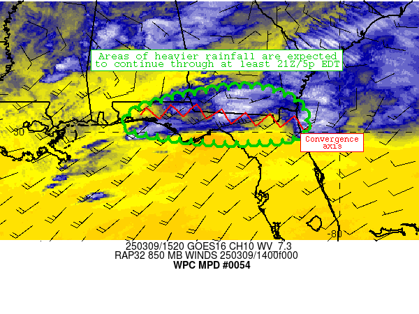
Mesoscale Precipitation Discussion 0054
NWS Weather Prediction Center College Park MD
1133 AM EDT Sun Mar 09 2025

Areas affected...portions of north Florida/Florida Panhandle and
southern Georgia

Concerning...Heavy rainfall...Flash flooding possible

Valid 091532Z - 092132Z

Summary...Flash flood potential should continue through 21Z/5p EDT
today as showers and thunderstorms repeat over areas that have
received 1-2.5 inches of recent rainfall.

Discussion...The flash flood risk across northern Florida and
adjacent areas of southern Georgia continues.  Latest radar mosaic
imagery indicates scattered coverage of thunderstorms moving from
west to east along an axis extending from near Pensacola to near
Jacksonville.  This axis is collocated with a nearly stationary
baroclinic zone, with localized ascent along that axis occurring
along the nose of 25-30 knot low-level jet centered over the
north-central Gulf just southeast of New Orleans.  Flow aloft
remains parallel to the axes of convergence/heaviest rainfall,
supporting continued training/repeating convective activity.
Moist thermodynamic profiles (1.5+ inch PW) and elevated
instability (around 1000 J/kg MUCAPE) continue to support robust
updrafts with local rain rates of 1-2 inches/hr at times beneath
training convection.

The ongoing meso-to-synoptic scale pattern supporting heavy rain
is expected to persist through at least 21Z today.  Some question
exists regarding convective coverage given slight ridging aloft
ahead of a positive tilt mid-level wave centered over northeast
Texas, although general consensus (supported by models and
observations) is that enough convective coverage will continue to
foster training and occasional 1-2 inch/hr rain rates.  Some of
these rates will fall on wet soils from prior rainfall over the
last 3-6 hours, promoting localized runoff.  Localized totals
exceeding 3 inches through 21Z cannot be ruled out.

Cook

ATTN...WFO...JAX...MOB...TAE...

ATTN...RFC...SERFC...NWC...

LAT...LON   31488330 30958141 29928135 29718329 29818531
            30188715 30888635
Download in GIS format: Shapefile
| KML
Last Updated: 1133 AM EDT Sun Mar 09 2025
