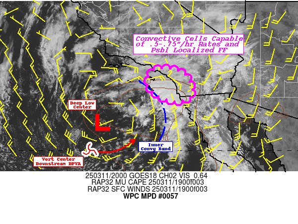
Mesoscale Precipitation Discussion 0057
NWS Weather Prediction Center College Park MD
421 PM EDT Tue Mar 11 2025

Areas affected...Coastal Southern California...Eastern Channel
Islands....

Concerning...Heavy rainfall...Flash flooding possible

Valid 112020Z - 120215Z

SUMMARY...Convective elements capable of .5-.75"/hr rates and
totals up to 1" pose localized possible flash flooding conditions
particularly in urban/rocky sloped ground conditions.

DISCUSSION...GOES-W Visible imagery continues to show a band of
convective cells along the northeast quadrant of the deep layer
cyclone.  An embedded lobe of vorticity is rounding the southern
base of the low providing subtle but sufficient diffluence aloft
across the southeastern California Bight with slowly increasing
DPVA to further enhanced vertical development.  WV suite also
suggests core of upper-level low and cold air advection is
filtering in steepening the lapse rates with MUCAPE reaching
500-750 J/kg within the band.  Low level confluent response along
the band and ample surface to 850mb of .5-.6" per CIRA LPW
combines to support .75-.9" total PWats within/below the
steepening lapse rates.  Cells have a healthy cauliform appearance
with boiling overshooting tops along the upstream edge; given
helicity of 100 m2/s2 and sfc-1km shear in the 15-20kt range, weak
rotation may be further supporting moisture flux into the cores of
the cells as they advance northeastward.   Given all the
parameters, cores of the cells will be capable of .5-.75"/hr
rates.

The uncertainty will continue to be the intersection with land
areas before the window of opportunity reduces as the vorticity
center rotates through reducing effective ascent pattern in
3-6hrs.  In the short-term, the upstream forcing should allow for
upstream/back-building of cells slowing forward propagation, but
once the DPVA passes through, cell motions could increase to
20+kts, limiting totals.   As such, cell cores are likely to
intersect San Clemente, potentially far eastern Catalina islands
with chance of up to 1" totals (HREF probs of 20-25%); however,
there is greater uncertainty toward reaching Orange county and
eastern San Diego county.  Still, if cell maintain convective
vigor (as suggested by recent HRRR and RAP solutions), even .5"/hr
rates would be near the FFG values in the area; so while localized
scattered incident or two of flash flooding is considered possible
through 03z.

Gallina

ATTN...WFO...LOX...SGX...

ATTN...RFC...CNRFC...NWC...

LAT...LON   33831750 33681704 33201664 32611654 32351696
            32301741 32611822 33091863 33781836
Download in GIS format: Shapefile
| KML
Last Updated: 421 PM EDT Tue Mar 11 2025
