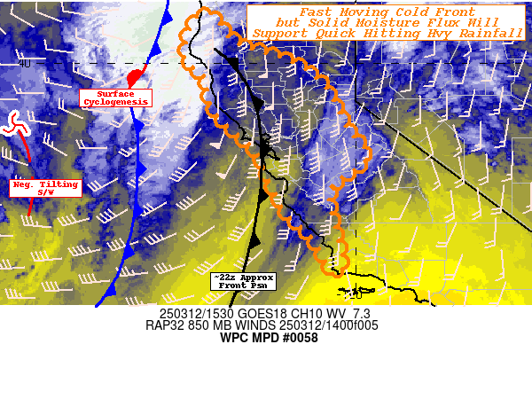
Mesoscale Precipitation Discussion 0058
NWS Weather Prediction Center College Park MD
1145 AM EDT Wed Mar 12 2025

Areas affected...Northwest to Central California...

Concerning...Heavy rainfall

Valid 121545Z - 130300Z

SUMMARY...Progressive cold front/moisture flux to produce 1-2"
totals in 4-6 hours, particularly only coastal ranges and lower
foothills of the Sierra Nevada Range.

DISCUSSION...GOES-W WV suite depicts a broad cold larger scale
trough across the northeast Pacific with a leading northwesterly
surge of colder air undercutting the base generally a degree or
two south of the 40N130W benchmark.  This is resulting in some
negative tilt to the base of the trof with downstream responses
noted in the expanding baroclinic shield cloud in the diffluence
aloft to the northeast nearing Cape Mendocino.  This is starting
to buckle the surface front and enhanced surface to low level
cyclogenesis near 39N and 127W backing low level flow and
increasing the low level jet to 50kts within the broader
isentropic ascent into the upper-level evacuation zone.   Total
moisture is not particularly impressive with this atmospheric
river with surface to 850mb CIRA LPW in the .5" range, however,
the narrow ribbon of mid to upper-level moisture is fairly
vertically aligned along/ahead of the cold front to support
reduced drying and perhaps some seeding from the mid-levels to
keep RH values higher than average in the band.

Still, the cold air advection is solid/strong resulting in a
fairly progressive frontal zone push from west to east.  Initial
core of the pre-frontal LLJ is starting to interact with the
Lost/Redwood near and south of Cape Mendocino.  The surface low
will track throughout the period into the Cape region and
potentially allow for additional surges of steepening lapse rates
for secondary convergence bands with weaker/narrow updrafts
intersecting the coastal region through the remainder of the day.
Rates should remain at or below .5"/hr averaging around .25" and
support 1.5-2.5" totals in favored orographics, but will come of
little concern given the rain forest nature to the area.  However,
as the cold front presses through, strong 40-50kts of flow will
intersect the coastal ranges toward the San Francisco bay through
21z.  As the cyclone continues to deepen, the directional
convergence along the front will go from 30-45 degrees up to 60-75
degrees increasing the overall convergence. The undercutting
upper-level shortwave may also have some peripheral influence of
steepening lapse rates aloft for some increased vertical ascent to
these convergence/ascent parcels allowing for narrow scattered
updrafts along the front with .25 to locally/occasionally reaching
near .5"/hr with 12z HREF .5"/hr probability values vacillating
around 30-50% changes north of the Bay through 21-22z time period.


...Central Californian coasts/Central Valley...
As the front drops south past the San Francisco Bay, the winds
will continue to be strong but also orient more favorably to the
Santa Cruz and eventually Santa Lucia ranges with near
orthogonality through solid depth in the 21-00z time period.  The
IVT strength will be peaking toward 500 kg/m/s with 850-700mb flow
starting to weaken slightly due to displacement southward from the
peak cyclogenesis...but still in the 40-50kt range.  The
combination of flux to steeper terrain will result in .5"/hr rates
being more likely, but given the southward translation of the cold
front may only result in 1-3 hours and overall totals are more
likely to be near 2-2.5", but an isolated 3" is not completely out
of the picture. HREF probability is over 80% for much of the
period along the Santa Lucia from 23-02z, though never even
reaches 10% for 1"/hr.

The moisture surge will have also filtered through the lower
terrain gap of the Bay and shower activity will also likewise
increased through the central valley into the lower foothills of
the Central Sierra Nevada.  Similarly, favored, nearly orthogonal
ascent will support .25-.33"/hr rates.  Totals of 1.5-2"+ may
result in increased runoff, but more likely beneficial in all but
the most prone areas.  Forward progression will continue with the
front, likely reaching Southern California/Cape Conception after
03z.

Gallina

ATTN...WFO...EKA...HNX...LOX...MTR...STO...

ATTN...RFC...CNRFC...NWC...

LAT...LON   41272379 40622330 40412284 40062178 39442086
            38272024 37511972 36702069 35812059 35162041
            34582037 34442061 35362112 36182194 37652263
            38432348 38782376 39122387 39692401 40072450
            40822442 41202419
Download in GIS format: Shapefile
| KML
Last Updated: 1145 AM EDT Wed Mar 12 2025
