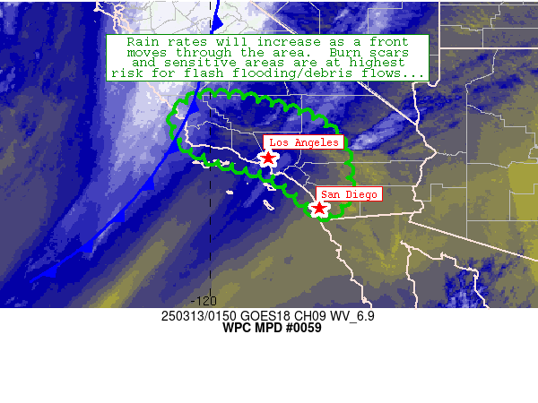
Mesoscale Precipitation Discussion 0059
NWS Weather Prediction Center College Park MD
1005 PM EDT Wed Mar 12 2025

Areas affected...portions of southern California

Concerning...Heavy rainfall

Valid 130205Z - 131405Z

Summary...A frontal band will translate from west to east across
southern California coastal ranges, resulting in 1-2 inch rainfall
totals - highest in terrain-favored areas.  This rainfall will
affect burn scars across the region, posing a risk of runoff,
flash flooding, and debris flows through at least 13Z/6a PDT.

Discussion...A strong Pacific cold front (currently located near
KPRB/Paso Robles, CA and KSBP/San Luis Obispo) was making steady
southeastward progress over the past several hours, and will
continue to do so across the discussion area through 13Z.  Along
and west of the front, areas of convection have produced 0.5-1
inch of rain over the past 3 hours - highest along coastal areas
between San Francisco and San Luis Obispo within the Santa Lucia
Range.  Minor flooding has also occurred across Alameda County.
These rainfall rates will continue to spread southeastward in
tandem with the front, while potentially increasing as depicted by
CAMs as the rainfall band reaches the Transverse Ranges and
adjacent areas near Los Angeles Metro through 06-12Z (11p-5a PDT)

As these rates spread southeastward, they will encounter fresh
burn scars from recent fires across the region.  These and other
sensitive areas will promote runoff along with the potential for
flash flooding and debris flows.  Models/obs indicate that a 3-5
hour period of moderate to heavy rain will affect the region, with
peak flash flood risk potential occurring in the 08Z-12Z (1a-5a
PDT) timeframe around the Los Angeles metro and adjacent areas of
the Tranverse Ranges.  The risk will peak farther southeast toward
San Diego and adjacent mountainous areas in the 12-14Z (5a-7a PDT)
timeframe.  Storm totals of 1-2 inches are expected (locally
higher in terrain-favored areas), and peak hourly rain rates
should mostly remain in the 0.5-0.75 inch range, locally higher.

Cook

ATTN...WFO...HNX...LOX...SGX...VEF...

ATTN...RFC...CNRFC...NWC...

LAT...LON   35732024 35711942 35461831 35081719 34491661
            33541642 32851661 32601709 32941746 33571821
            33871899 34142000 34632080 35342090
Download in GIS format: Shapefile
| KML
Last Updated: 1005 PM EDT Wed Mar 12 2025
