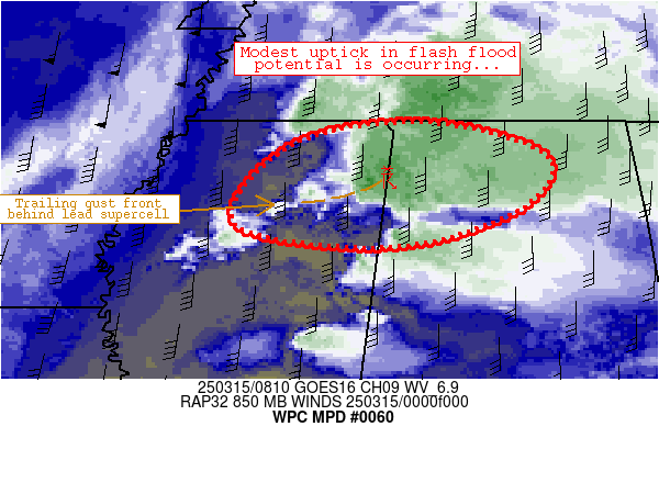
Mesoscale Precipitation Discussion 0060
NWS Weather Prediction Center College Park MD
437 AM EDT Sat Mar 15 2025

Areas affected...northeastern Mississippi and northwestern Alabama

Concerning...Heavy rainfall...Flash flooding possible

Valid 150822Z - 151122Z

Summary...Localized 1.5-2.5 inch/hr rain rates should continue for
the next couple hours or so.  Convective evolution thereafter is a
bit uncertain.  Isolated flash flooding is possible.

Discussion...A dominant, right-moving supercell has persisted for
several hours while reaching Itawamba County, Mississippi near the
MS/AL border.  This supercell has maintained broad rotation within
a moist and strongly sheared airmass.  Convection immediately
upstream (along and north of its gust front) has enabled a
scenario for localized training and rain rates approaching 2
inches/hr from near Okolona, MS northeastward to near Fulton, MS.

As this lead supercell progresses into Alabama, increasing
convective coverage has materalized upstream in areas near Tupelo,
Columbus, and Greenwood.  The cells are embedded within strong,
broadly confluent 850mb flow exceeding 45 knots areawide, which
continues to maintain moist/unstable thermodynamic profiles in the
immediate wake of the supercell.  It appears that this confluent
low-level jet structure should be maintained for multiple hours
this morning despite 1) departing forcing for ascent with a
mid-level vort max moving away toward the upper Midwest and 2)
renewed mid-level troughing across Texas that should result in a
gradual backing of 850mb flow.

The ongoing supercell along the MS/AL border should eventually
weaken as it reaches less stable air especially across
north-central/northeastern Alabama.  Upstream convection, however,
should continue to support localized runoff issues as 1-hour FFG
thresholds (in the 1.5-2 inch range) are approached by localized
repeating/training cells across the discussion are through the
morning - especially in areas that have already had rainfall.
Isolated flooding is possible, although this event appears to be
perhaps the beginning of a more synoptically evident flash flood
event expected to unfold later today/tonight.

Cook

ATTN...WFO...BMX...HUN...JAN...MEG...

ATTN...RFC...LMRFC...SERFC...NWC...

LAT...LON   34998775 34638646 34078673 33678809 33918976
            34758916
Download in GIS format: Shapefile
| KML
Last Updated: 437 AM EDT Sat Mar 15 2025
