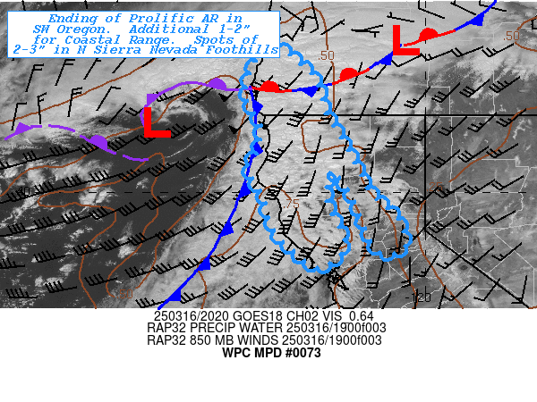
Mesoscale Precipitation Discussion 0073
NWS Weather Prediction Center College Park MD
442 PM EDT Sun Mar 16 2025

Areas affected...Southwest Oregon...Northern California...

Concerning...Heavy rainfall

Valid 162045Z - 170730Z

SUMMARY...Flooding risk reducing as cyclone makes landfall and
warm conveyor belt presses quickly southward to intersect coastal
range and northern Sierra Nevada Foothills with heavy rainfall.

DISCUSSION...Southwest Oregon has been experiencing prolonged
moderate rainfall for over 24hrs at this point with large areas of
4"+ totals across much of the area of Coos, Douglas, Josephine and
northern Jackson counties and spots in the boreal rain forests of
Curry county in the 8-10" ranges.  Longer duration flooding has
been going in atypical locations with the prolonged heavy
rainfall.   The strong onshore moisture flux will be ending in the
next hour or so, but a strong surface wave can be seen with a
secondary one further west along an old occluded front.  Steeper
lapse rates due to CAA aloft and some modest retention of moisture
along the boundary may allow for some scattered shower activity to
cross SW OR along the occluded front into the stationary front
that crosses into central OR.  Rates up to .25-.33"/hr are
possible but will be more scattered in nature and may result in
those ranges of totals in a sub-hourly manner.  This is not likely
to further contribute to enhanced flooding, but will slow its
ending for a few more hours.

Further south...GOES-W Visible imagery shows the cold front and
more directed atmospheric river/warm conveyor belt has started a
southward progression.  The core of .75-.9" total PWat continues
to be advected from strong 40-50kt 850mb winds allowing for IVT
values to remain at 650-700 kg/m/s near the triple point that is
near the OR/CA coastline and southeastward.   Upper-level
height-falls will continue to support increasing south and
eastward propagation of the cold front and therefore
onshore/upslope moisture flux.  Occasional rates of .33-.5"/hr are
possible especially along the steepest inclines of the northern
Sierra Nevada foothills, but duration of moderate rainfall is
likely to be limited to a few hours and likely only result in
spotty totals of 1.5-3" in traditional locations in Butte, Tamaha
and Yuba counties.  Coastal Ranges are more likely to see
1.5-2.5", reducing to .75-1.5" by the time the plume further
weakens (wind speeds down to below 35kts) and IVT values fall
below 400 kg/m/s...nearing the mouth of San Francisco Bay between
03-06z.   A secondary weaker band of scattered showers will wrap
around the surface low as it translates east and affects the NW
California after 00z as well, adding another .5-.75" for the
totals.  Bringing the overall event to close in the early morning
hours tonight.

Gallina

ATTN...WFO...EKA...MFR...MTR...STO...

ATTN...RFC...CNRFC...NWRFC...NWC...

LAT...LON   43762376 43402333 42922284 42092262 41122202
            39922140 39382078 38672050 38392087 38572132
            39852189 40562243 39762260 38632211 38022277
            38442338 39022398 39812419 40592462 41122434
            41812430 42392466 42882466 43412443 43742423
Download in GIS format: Shapefile
| KML
Last Updated: 442 PM EDT Sun Mar 16 2025
