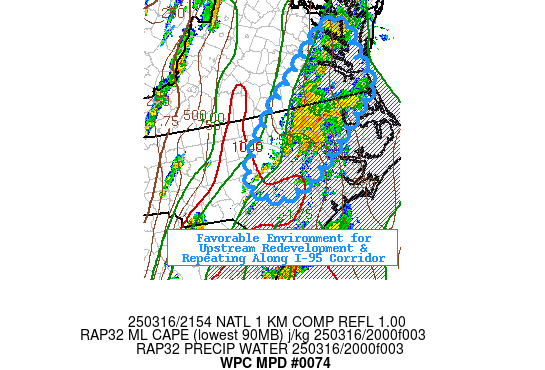
Mesoscale Precipitation Discussion 0074
NWS Weather Prediction Center College Park MD
558 PM EDT Sun Mar 16 2025

Areas affected...Northeast NC...Southeast VA

Concerning...Heavy rainfall...Flash flooding possible

Valid 162200Z - 170400Z

SUMMARY...Continuation of stronger cells capable of 1.5-2"/hr
rates with upstream redevelopment probable resulting in possible
streets of 3"+ totals and localized flash flooding conditions.

DISCUSSION...RADAR mosaic depicts a cluster of stronger elongated
updrafts in proximity to the I-95 corridor tracking through an
area that had already seen an earlier round wetting the grounds
with spots of .75-1.5" as far north as Petersburg/Wakefield, VA.
These cells are aided by a divergence maxima rounding the cyclonic
edge of a fairly laminar upper-level jet.   This pattern is
expected to remain similar with a very slow eastward progression;
as such, 500-1000 thickness ridge resides along/just east of the
I-95 corridor and with solid 45-50kts of moist 850mb flow, there
is ample potential for additional upstream redevelopment.
Alignment of the moisture axis and instability axis appears to be
fairly stable in placement as well with upstream well of 1000-1500
J/kg of MLCAPE to the west and 1.5 to 1.75" of total PWats
eastward.  Solid deep layer confluence is providing the upstream
convergence to allow for back-building/redevelopment.  However,
the updraft strength is offset a bit being on the gradient of the
instability axis, resulting in inconsistent, narrow updrafts but
stronger cloud base moisture flux allows for efficient loading to
support 1.5-2"/hr rates.  Lengths of the updrafts should allow for
an hour or so of training for streaks of 1.5" with each
pulse/round of convection moving northward.

Stronger convergence along the cold front as the base of the trof
drifts eastward is likely to occur after sunset and likely spell
the last round, this may be after 04z (the end valid time of this
message) and trends will need to be continually monitored for
additional training and longer duration totals of 3-4" when all is
over earlier tomorrow morning.   Area has been fairly dry and FFG
values are high (especially further east in the Coastal Plain);
however, given each round slowly infiltrated and saturates the
upper soils reducing it for the next round.  While, an incident or
two of flash flooding is possible, it is more likely to be
isolated, lower-end with greatest risk of higher magnitude of
flooding in urban locations such as Raleigh, Rocky Mount, Emporia,
Petersburg and the Hampton Roads vicinity of SE VA.

Gallina

ATTN...WFO...AKQ...MHX...RAH...

ATTN...RFC...MARFC...SERFC...NWC...

LAT...LON   37897661 37867619 37297617 36797596 36597603
            36207647 35347760 35007846 35417909 36347852
            37367736
Download in GIS format: Shapefile
| KML
Last Updated: 558 PM EDT Sun Mar 16 2025
