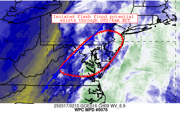
Mesoscale Precipitation Discussion 0076
NWS Weather Prediction Center College Park MD
1024 PM EDT Sun Mar 16 2025

Areas affected...portions of the Mid-Atlantic

Concerning...Heavy rainfall...Flash flooding possible

Valid 170224Z - 170824Z

Summary...Gradually deepening convection will migrate
northeastward across the discussion area for the next several
hours.  Rates of 1-2 inches/hr are expected - highest across
eastern Maryland into the DelMarVa.  Isolated flash flooding is
possible in this regime.

Discussion...Several atmospheric factors are combining to result
in increasing convective coverage and heavy rainfall across the
discussion area, including: 1) convergence along a surface cold
front extending from Charlottesville, VA to near Lancaster, PA, 2)
strong low-level flow/warm advection, which was maintaining deeper
convection near/east of Richmond, VA while also maintaining ~500
J/kg SBCAPE and 1-1.5 inch PW ahead of the front, 3) advancing
mid/upper level vorticity (and ascent) from troughing centered
over the Ohio Valley and central Appalachians.

As these features continue to evolve slowly eastward over the next
few hours, axes of heavier rainfall will continue to spread
east/northeastward along and ahead of the aforementioned cold
front.  Spots of 1 inch/hr rain rates can be expected at times
nearer the front, while heavier rainfall (including 2-2.5 inch/hr
rain rates) could occur out ahead of the front as is currently
being estimated near/east of Richmond, VA.  FFGs across the
discussion area are lowest across the DC-to-Philadelphia I-95
corridor (0.5-1.0 inch/hr) and these thresholds could be eclipsed
on an isolated basis over the next 2-4 hours as the front makes
its way eastward through the region.  Heavier rain rates are
expected east of I-95 toward the DelMarVa, although it appears
that ground conditions/FFGs are a bit less sensitive in these
areas, suggestive of more isolated flash flood potential.  2-3
inch rainfall totals are expected across the DelMarVa through 08Z
tonight, with lighter totals expected elsewhere.

Cook

ATTN...WFO...AKQ...CTP...LWX...PHI...RNK...

ATTN...RFC...MARFC...NWC...

LAT...LON   40787539 40437427 39587434 38027549 37357691
            37677889 38807814 40237663
Download in GIS format: Shapefile
| KML
Last Updated: 1024 PM EDT Sun Mar 16 2025
