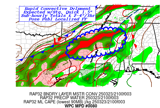
Mesoscale Precipitation Discussion 0080
NWS Weather Prediction Center College Park MD
656 PM EDT Sun Mar 23 2025

Areas affected...Northern LA...Southern AR...Central MS...

Concerning...Heavy rainfall...Flash flooding possible

Valid 232300Z - 240430Z

SUMMARY...Strong moisture flux convergence with initial convective
development will allow for very quick moisture loading and strong
downdrafts capable of quick 2"/hr rates (15-minute totals of
1-1.5" psbl).  As cold front moves east, interaction with older
warm sector convection may allow for localized repeating/training
and spot totals of 2-3" in 1-2hrs resulting in possible flash
flooding.

DISCUSSION...GOES-E Visible/10.3um and RADAR mosaic denote
scattered destabilization occurring across the warm sector mainly
along the Lower Mississippi River Valley at the intersection of
the nose of instability axis (2500-3000 J/kg) of MLCAPE that
extends from the Heart of Texas into northeast LA and the nose of
the deepest sfc to 850mb moisture core (LPW of .8-.9") across
south-central LA into northeast LA.  This boundary layer moisture
is quickly advancing northward toward a southward pressing/well
defined (steep isentropes) that is bisecting AR from NE to SW.
These cells are expected to be slower moving but with steering
more northward toward the frontal zone before effective bulk shear
increases due to stronger flow aloft across the Delta Region into
the Bootheel of MO.  The collision of the air masses is likely to
result in rapid convective development along the front from NW MS
across S AR into N LA and eastern TX mainly in the 01-02z time
frame.  There has been solid signal throughout the day toward this
time frame, but trend in the HRRR is a bit earlier and more
focused resulting in very strong moisture flux loading to the
line. Stronger mid-level dry air will likely aid stronger
downdrafts due to mixing but given loading is expected to have
heavy rainfall totals in quick sub-hourly amounts.

Experimental HRRR 15-min estimates 1-1.25" at onset around 0130z
become near 1.75" by 02-03z across N LA.  Hourly totals of 2-2.5"
seem plausible given weaker overall steering before cold
front/outflow boundaries begin to organize and advance eastward.
While soil moisture is about 45-55% (in all but the braided
portions of the MS River...65+% there), this is running in the
10-15th percentile, suggesting upper-soils may initially not allow
much infiltration).  Still, the spotty/smaller areal coverage may
limit the overall magnitude of flash flooding suggesting highly
focused/localized at least initially across S AR/N LA for spotty
possible flash flooding.   It is only later toward 04-06z with
some organization and potential west to east training that
localized totals may reach 2-4" through 06z.  18z HREF and recent
HRRR runs support the best probability to be in proximity to the
AR/LA/MS intersection and points east-northeastward.   Confidence
is increasing toward possible scattered incidents of flash
flooding through this time period before cells become too
scattered/progressive generally after 06z, but will continue to
monitor trends closely.

Gallina

ATTN...WFO...JAN...LZK...MEG...SHV...

ATTN...RFC...LMRFC...SERFC...WGRFC...NWC...

LAT...LON   34389006 34318925 34248863 33868836 33378837
            32958857 32398922 32039070 31829179 31709325
            31989383 32779367 33569269 34099146
Download in GIS format: Shapefile
| KML
Last Updated: 656 PM EDT Sun Mar 23 2025
