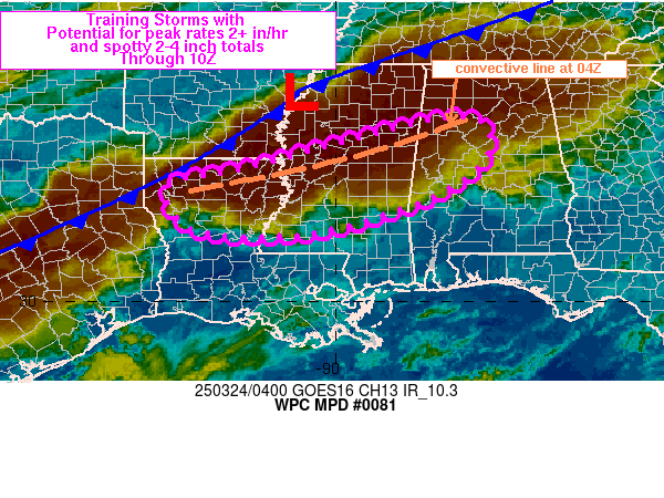
Mesoscale Precipitation Discussion 0081
NWS Weather Prediction Center College Park MD
1221 AM EDT Mon Mar 24 2025

Areas affected...northern LA into central MS and western AL

Concerning...Heavy rainfall...Flash flooding possible

Valid 240420Z - 241020Z

Summary...Periods of training thunderstorms may produce areas of
isolated to widely scattered flash flooding through 10Z across
portions of northern LA, central MS and western AL. Peak rainfall
rates between 1-3 in/hr and spotty totals of 2-4 inches are
expected through 10Z.

Discussion...04Z regional radar imagery showed a WSW to ENE line
of thunderstorms that extended from northern LA into northern AL.
This line formed earlier within an axis of pre-frontal confluence
and has since become the dominant area of convection across the
Lower Mississippi Valley. Farther north, closer to the cold front
itself, were a few scattered thunderstorms, mainly located in TN.
04Z SPC mesoanalysis data showed the environment from northwestern
AL to northern LA contained 500 to 1500+ J/kg MLCAPE (highest to
the west over northern LA) and 1.2 to 1.5 inches of PWAT.

Expectations are for the line of storms to continue advancing
southeastward, ahead of the cold front and along the leading edge
of rain-cooled outflow which has since formed behind the advancing
line. While storm motion should remain progressive and not pose a
significant threat for flash flooding, the environment is, and
will continue to be, capable of producing 0.5 to 1.0 inches of
rain in 15 minutes given forecasts of lingering instability over
the next several hours. Where convective orientation matches the
mean steering flow from the WSW, training will produce 1-2 in/hr
rates, perhaps exceeding 2 inches in an hour. The result will be
spotty 2-4 inches of additional rainfall through 10Z, although the
higher end of that scale is considered a much lower probability of
occurrence. Given relatively high flash flood guidance values
(especially over southern portions of the MPD threat area), any
areas of flash flooding that develop will likely be tied to areas
of poor drainage, particularly those of urban nature.

Otto

ATTN...WFO...BMX...JAN...MEG...MOB...SHV...

ATTN...RFC...LMRFC...SERFC...NWC...

LAT...LON   33898746 33168677 32388762 31658960 31399127
            31559306 32459350 32829180
Download in GIS format: Shapefile
| KML
Last Updated: 1221 AM EDT Mon Mar 24 2025
