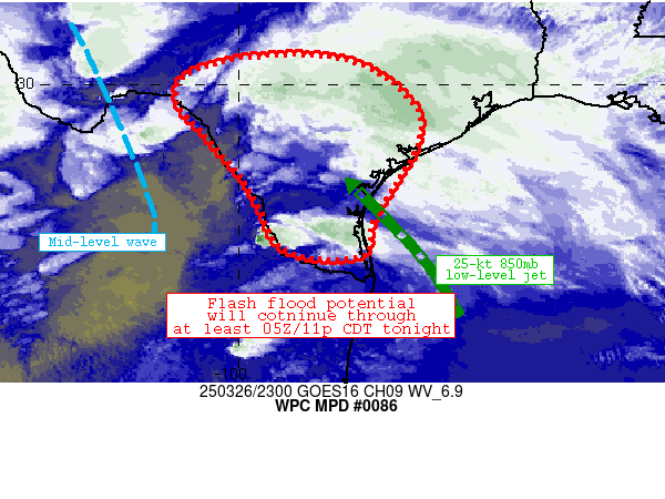
Mesoscale Precipitation Discussion 0086
NWS Weather Prediction Center College Park MD
719 PM EDT Wed Mar 26 2025

Areas affected...portions of south Texas

Concerning...Heavy rainfall...Flash flooding likely

Valid 262318Z - 270518Z

Summary...Areas of heavy rainfall continue to move slowly across
the discussion area, with redevelopment of deep/intense convection
noted along/just west of the Rio Grande recently.  Flash flood
potential (locally significant) should continue through 05Z/11p
CDT and likely beyond.

Discussion...Over the past 6 hours, scattered to numerous
thunderstorm activity has produced areas of 1-5 inch rainfall
amounts - highest northwest of Corpus Christi and northwest of
McAllen.  Prior dry conditions and high FFGs suggested that these
rainfall totals have likely resulted only minimal impacts so far,
though wetting soils should gradually result in the region
becoming more susceptible to flash flooding as additional rainfall
develops across the region tonight.

Meanwhile, radar/satellite mosaic imagery indicates
redeveloping/strengthening convection along and either side of the
Rio Grande Valley, with additional strengthening storms located
just north of Corpus Christi.  Wind fields aloft have strengthened
across the discussion area in tandem with better ascent/lift,
which is the likely culprit for the recent increase in convective
coverage.  Increased wind shear has enabled a few of the
convective structures to exhibit right/deviant motion with speeds
as slow as 5-10 knots and rain rates exceeding 2 inches/hr.

Over time, concern exists that convection near the Rio Grande
could grow upscale into one or more convective complexes.  These
complexes will move very slowly while continuing to exhibit
embedded rotation and occasional cell mergers that should enhance
rain rates.  Localized areas of 3-5 inch rainfall totals are
expected, and significant flash flooding could become a great
concern if higher rain rates were to materialize in
sensitive/urbanized portions of the discussion area.

A secondary concern for upscale growth/backbuilding exists
near/just north of Corpus Christi where low-level confluence
exists on the northern extent of 20-25 kt 850mb flow.  A few of
these areas have already experienced 2-5 inch rainfall totals
today.  Additional rainfall could result in flash flooding
especially if a more persistent convective band could become
established.

Cook

ATTN...WFO...BRO...CRP...EWX...HGX...SJT...

ATTN...RFC...WGRFC...NWC...

LAT...LON   30599832 30329724 29809654 29259617 28569631
            27869674 27099719 26499730 26349770 26379853
            26649920 27329952 28049993 28730053 29050080
            29620131 30180112 30559991
Download in GIS format: Shapefile
| KML
Last Updated: 719 PM EDT Wed Mar 26 2025
