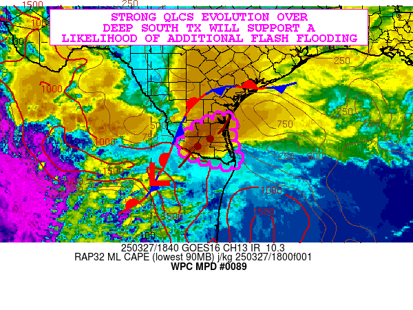
Mesoscale Precipitation Discussion 0089
NWS Weather Prediction Center College Park MD
257 PM EDT Thu Mar 27 2025

Areas affected...Deep South TX

Concerning...Heavy rainfall...Flash flooding likely

Valid 271857Z - 280057Z

SUMMARY...A strong and well-organized QLCS gradually settling down
through Deep South TX will be capable of producing very heavy
rainfall rates and a general likelihood for flash flooding heading
into the early evening hours.

DISCUSSION...GOES-E IR satellite imagery in conjunction with
dual-pol radar shows a well-defined QLCS gradually settling
eastward down across Deep South TX. This convective complex is
being strongly favored by the ejection of left-exit region
upper-level jet dynamics across the lower Rio Grande Valley
downstream of a deeper layer trough crossing northern Mexico and
parts of the southern High Plains.

This energy is also interacting with a quasi-stationary frontal
zone and the pooling of a modestly unstable airmass characterized
by MLCAPE values of near 1000 J/kg. While instability is rather
modest, there is a rather favorable shear environment for a
continuation of organized convection over Deep South TX with
stronger mid-level winds helping to support as much as 40+ kts of
effective bulk shear. Some additional uptick in diurnal heating
over the next few hours should support some additional boundary
layer destabilization and this coupled with a convergent and moist
low-level south-southeasterly jet of 30 to 40 kts should support
convection with high rainfall rates capable of reaching 2 to 3
inches/hour with the stronger storms. In fact, the latest
CIRA-ALPW data shows a notable surge/wave of higher PWs/moisture
concentrated in the SFC/850 mb layer lifting northwest out of the
Bay of Campeche and taking aim on Deep South TX. Speed convergence
associated with this in conjunction with the implied stronger
moisture transport will further enhance the rainfall rate
potential over the next few hours.

The 12Z HREF guidance along with numerous runs of the HRRR
continue to struggle with the details and evolution of the ongoing
convective activity more regionally over southern TX. Accounting
for the current activity, the HRRR is closest from a convective
mode/object perspective, but is way too slow with its evolution.
Basically the HRRR 00Z to 06Z/Fri QPF signal is likely to occur
more over the next 6-hours based on the latest satellite and radar
trends.

High rainfall rates and rather slow cell-motions with the QLCS
evolution should favor additional rainfall amounts of as much as 3
to 5 inches, and especially where any transient areas of
cell-training can occur. Given the wet antecedent conditions from
earlier heavy rainfall, these additional rains are likely to cause
additional areas of flash flooding heading into the early evening
hours, and this will include the Brownsville vicinity.

Orrison

ATTN...WFO...BRO...CRP...

ATTN...RFC...WGRFC...NWC...

LAT...LON   27509751 27429722 26879728 25919702 25739713
            25959801 26199884 26569899 27159840
Download in GIS format: Shapefile
| KML
Last Updated: 257 PM EDT Thu Mar 27 2025
