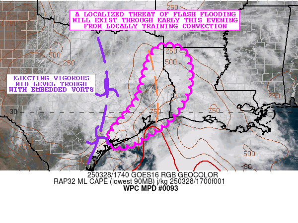
Mesoscale Precipitation Discussion 0093
NWS Weather Prediction Center College Park MD
211 PM EDT Fri Mar 28 2025

Areas affected...Eastern TX...Far Western LA

Concerning...Heavy rainfall...Flash flooding possible

Valid 281810Z - 290010Z

SUMMARY...A localized threat for some flash flooding will exist
going through the early evening hours from heavy showers and
thunderstorms that may train over the same location.

DISCUSSION...The early afternoon GOES-E visible satellite imagery
shows an increasingly expansive CU/TCU field over eastern TX as
vigorous mid-level shortwave/vort energy lifting northeastward
interacts with a surface trough and the pooling of modest boundary
layer instability. MLCAPE values are on the order of 500 to 1000
J/kg with a seasonably moist environment characterized by PWs of
1.5 to 1.75 inches.

Radar does show a band of showers and thunderstorms organizing in
a general south to north fashion over far eastern TX, and as
additional diurnal heating/solar insolation contributions to
further boundary layer destabilization this afternoon, there
should be some additional expansion of convection which should
tend to become locally well-organized given the presence of 30 to
40+ kts of effective bulk shear. This will include a convective
threat to the middle and upper TX coast and the greater
Houston/Galveston metropolitan area.

The 12Z HREF guidance shows 50 to 70 percent probabilities of 1 to
2 inch/hour rainfall rates with the storms this afternoon, and
some localized exceedance of 2 inch/hour rates will be possible
especially for areas of far eastern TX just west of the LA border
where the axis of stronger instability and relatively stronger
surface moisture convergence is expected to be focused.

Given concerns for some localized cell-training, some storm total
amounts by 00Z (7PM CDT) may reach as high as 3 to 5 inches. FFG
values across the region are rather high, but the HREF guidance
does suggest some low-end probabilities of exceedance which
suggests a localized concern for flash flooding with an emphasis
generally on the more urbanized locations.

Orrison

ATTN...WFO...CRP...HGX...LCH...SHV...

ATTN...RFC...LMRFC...WGRFC...NWC...

LAT...LON   33089412 32769304 31189288 29729373 28859497
            28499554 28399633 28699661 29309630 30539529
            32419473
Download in GIS format: Shapefile
| KML
Last Updated: 211 PM EDT Fri Mar 28 2025
