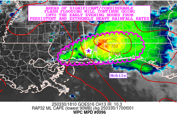
Mesoscale Precipitation Discussion 0096
NWS Weather Prediction Center College Park MD
223 PM EDT Sun Mar 30 2025

Areas affected...Far Southern MS...Southwest AL...Western FL
Panhandle

Concerning...Heavy rainfall...Flash flooding likely

Valid 301823Z - 302323Z

SUMMARY...Very heavy rainfall continues to impact areas of far
southern MS, southwest AL and the western part of the FL
Panhandle. Extremely heavy rainfall rates persisting over the
region with locally backbuilding and training cells will yield
areas of locally significant/considerable flash flooding over the
next few hours.

DISCUSSION...GOES-E IR satellite imagery continues to show a
cluster of strong cold-topped convection with numerous
overshooting tops over areas of the central Gulf Coast region
extending from far southern MS eastward across southwest AL and
into the western FL Panhandle. The convection continues to be
anchored along a general north/south convergence axis and within a
well-defined instability gradient.

MLCAPE values of 1000 to 1500 J/kg and PWs of 1.5 to 1.75 inches
are in place across the area which coupled with some occasional
mesocyclone activity has been yielding extreme rainfall rates of 2
to 4 inches/hour with the stronger cores. Already there are
Radar-QPE values across parts of Jackson County of 8 to 10 inches
where significant backbuilding of convection has occurred.

Very strong overshooting top activity has yielded some cloud top
temperatures recently to near -70 C and there has been an overall
expansion of convection over the last few hours to include more
areas of southwest AL and the western FL Panhandle. The GOES-E
visible satellite imagery shows some low-level cloud street
activity upstream over southeast LA and southern MS as a
destabilizing boundary layer couples with moist southwest flow.
This low-level feed of moisture and instability should continue to
support the downstream convective clusters, with a favorable
backbuilding environment continuing at least in the short term.

Additional rainfall totals of 3 to 6+ inches are expected given
the very high rainfall rates and convective mode going through
early this evening. The recent HRRR guidance has been supporting
this, and additional areas of flash flooding are likely which will
include locally significant/considerable urban flash flooding
impacts. The Mobile metropolitan area will need to continue to
closely monitor this activity for enhanced rainfall and flash
flooding concerns over the next few hours.

Orrison

ATTN...WFO...LIX...MOB...TAE...

ATTN...RFC...LMRFC...SERFC...NWC...

LAT...LON   31338653 31008611 30598623 30358667 30258801
            30258931 30748918 31278787
Download in GIS format: Shapefile
| KML
Last Updated: 223 PM EDT Sun Mar 30 2025
