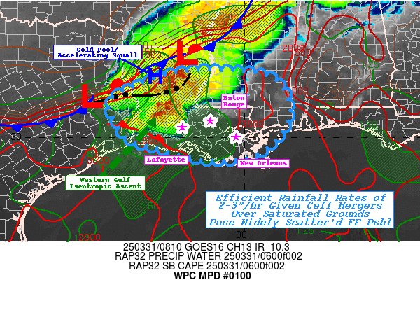
Mesoscale Precipitation Discussion 0100
NWS Weather Prediction Center College Park MD
425 AM EDT Mon Mar 31 2025

Areas affected...Southern LA...Far Southeast TX...Southwest MS...

Concerning...Heavy rainfall...Flash flooding possible

Valid 310830Z - 311400Z

SUMMARY...Merging clusters with quick 2-3" totals and intersection
with recently flooded/nearly saturated soils pose localized
scattered incidents of possible flash flooding/rapid inundation
through Monday morning.

DISCUSSION...Regional RADAR mosaic shows a mature cluster to wedge
of thunderstorms across the northern Piney Woods of E TX into
north-central LA starting to become increasingly progressive
toward the southeast given strengthening cold pool from earlier
storms as well as height-falls/shortwave trough passing across the
area currently.   Additionally, diurnally driven onshore
flow/strengthening of the western Gulf low-level jet has recently
lead to broad WAA isentropic ascent from the Sabine River eastward
into SW LA.  Deep layer moisture and confluent low-level flow
accelerating into the approaching line of convection will result
in very strong moisture flux convergence and cell mergers over the
next few hours.  Given total PWats of 1.75" and doubling within
the low-level column should increase efficiency to support rates
of 2-2.5"/hr with perhaps an isolated 3"/hr rate total.
Southeastward propagation should limit duration, but widely
scattered spots of 2-3" totals are likely to occur.

The random scattered may overlap with recently flooded locations
over the last few days and may reaggravate flooding given limited
infiltration expected.  NASA SPoRT 0-40cm soil saturation are well
above average (into the 90th percentiles) with ratios above
70-75%. Additionally, the high rates should traverse a few prone
cities of Baton Rouge, Lafayette, and eventually New Orleans and
Biloxi/Gulfport toward 14-15z posing urban rapid inundation
flooding possible as well.

Gallina

ATTN...WFO...JAN...LCH...LIX...MOB...SHV...

ATTN...RFC...LMRFC...WGRFC...NWC...

LAT...LON   32229098 32118951 31828886 31338859 30998847
            30558853 29908895 29388970 29259051 29279145
            29469234 29719310 29919382 30529429 31199452
            31629377 32159228
Download in GIS format: Shapefile
| KML
Last Updated: 425 AM EDT Mon Mar 31 2025
