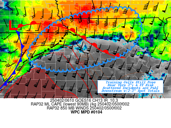
Mesoscale Precipitation Discussion 0104
NWS Weather Prediction Center College Park MD
229 AM EDT Wed Apr 02 2025

Areas affected...Northeast KS...Northwest MO...Far Southeast
NEB...Far Southwest IA...

Concerning...Heavy rainfall...Flash flooding possible

Valid 020630Z - 021200Z

SUMMARY...A few more hours of training thunderstorms capable of
1.5-1.75"/hr rates and localized totals of 3"+ continuing flash
flooding risk.  However, veering flow will result in increasing
forward cell motions limiting overall totals and flooding risk
eastward into N MO.

DISCUSSION...Surface and RAP analysis fields show maturing surface
to 850mb low across south-central NEB continuing to pivot slowly
with expanding warm sector across eastern KS, spreading into
western MO.  Pressure falls have been backing warm sector flow/LLJ
proving solid moisture and unstable air advection toward the
frontal zone.  Isentropic ascent has been redeveloping
thunderstorms along a WSW to ENE line from Salina to Manhattan
toward St. Joseph.  The prolonged isentropic ascent from low level
moisture convergence from the warm sector has resulted in
saturating the deep profile for rainfall rates to reach 1.75-2"/hr
over the last few hours resulting in a streak of 2-4" totals and
long swath of MRMS FLASH unit stream flows reaching 400 cfs/sqmi
from central KS into NE KS.  While the warm sector remains
unstable with MLCAPEs of 2000 J/kg, the upper-level shortwave axis
is swinging from weak positive to neutral transferring
cyclogenesis further southwest along the cold front and resulting
in increasing height-falls.  As such, LLJ is starting to veer
slightly as the initial surface wave matures/occludes over the
next 2-3 hours reducing orthogonal upglide.  As the cold front
advances eastward, there will be increasing convective development
southward with increased forward propagation, reducing duration of
heavy rainfall and capability of saturating the deeper layer
profile.

As a result, the best training will still occur across NE KS into
far NW MO with rates of 1.5-1.75"/hr totals expected. Spots
already receiving 1-2" may still reach 3"+ totals.  FFG values
decrease steadily east and north with 1.5"/1hr and 2-2.5"/3hrs are
still in the realm of being exceeded in the shorter term though
likely decreasing steadily further eastward into south-central
IA/north-central MO. Strong up/downdrafts capable of a quick
1-1.5" sub-hourly total are still within a low possibility of
inducing some flooding concerns especially near urban centers and
traditionally prone flooding areas, but the progressive nature
should limit it to those locations only through the morning.

Gallina

ATTN...WFO...DMX...EAX...OAX...TOP...

ATTN...RFC...ABRFC...MBRFC...NCRFC...NWC...

LAT...LON   40989315 40739264 40179248 39639269 39199314
            38889380 38609485 38489601 38989700 39649673
            40399590 40859437
Download in GIS format: Shapefile
| KML
Last Updated: 229 AM EDT Wed Apr 02 2025
