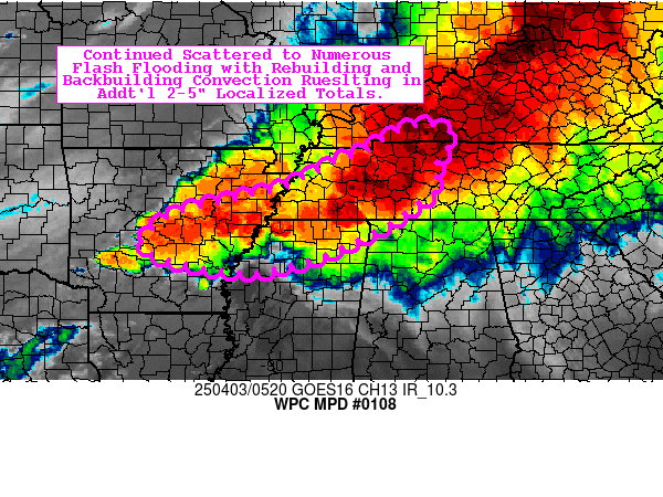
Mesoscale Precipitation Discussion 0108
NWS Weather Prediction Center College Park MD
130 AM EDT Thu Apr 03 2025

Areas affected...Mid-South into the TN Valley

Concerning...Heavy rainfall...Flash flooding likely

Valid 030530Z - 031130Z

Summary...Continued scattered to numerous flash flooding with
rebuilding and backbuilding convection resulting in additional
2-5" localized totals.

Discussion...A large line of thunderstorms (QLCS) extends from the
Lower Great Lakes and OH Valley to the Ark-La-Tex, and the segment
of the line across West/Middle TN into north MS continues to stall
with favorable conditions for backbuilding in the near term.
Ongoing deep convection continues to produce rainfall rates of up
to 1-2"/hr with ample upper-level divergence in the vicinity of
the right-entrance region of a large upper-level jet streak. The
mesoscale environment from north MS to West/Middle TN is
characterized by SB CAPE of 750-1500 J/kg, precipitable water
values of 1.3-1.7 inches (near the max moving average, per BNA
sounding climatology), and effective bulk shear of 55-65 kts. With
the stalling of the QLCS in this extraordinary environment, given
a 40-50 kt low-level jet ushering in continued strong moisture
transport and resulting deep layer moisture flux convergence,
renewed convection with heavy rainfall is expected.

Looking at a consensus of the latest hi-res models, an additional
2-5" of rainfall appears likely across portions of north MS into
West/Middle TN. While the bulk of this rainfall is expected over
areas that have received little to no rainfall so far, some
portions of West TN have already received some heavy rainfall (up
to 1-3"). Given the current presentation of radar (with impress
discrete cell signatures reforming in the MS Delta), models may be
underestimating the intensity and persistence of cells which may
backbuild farther north into northeast AR and far West TN.
Continued scattered to numerous areas of flash flooding are
likely, and some flooding may become significant in urban areas
where cells effectively backbuild.

Churchill

ATTN...WFO...HUN...JAN...LMK...LZK...MEG...OHX...PAH...

ATTN...RFC...ABRFC...LMRFC...OHRFC...SERFC...NWC...

LAT...LON   37018687 36798638 36438652 36098678 35818667
            35608671 35348709 35048751 34998757 34938769
            34668816 34318892 34028976 33959022 33879069
            34039183 34269269 34499294 34759274 35139219
            35379119 35519058 35658999 35898946 36218884
            36468816 36868754
Download in GIS format: Shapefile
| KML
Last Updated: 133 AM EDT Thu Apr 03 2025
