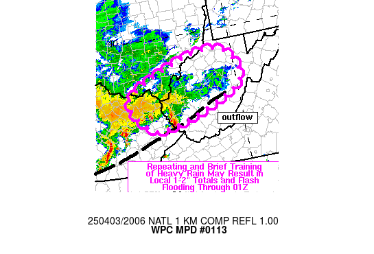
Mesoscale Precipitation Discussion 0113
NWS Weather Prediction Center College Park MD
408 PM EDT Thu Apr 03 2025

Areas affected...upper OH Valley

Concerning...Heavy rainfall...Flash flooding possible

Valid 032006Z - 040105Z

SUMMARY...Repeating and brief training of cells could result in
localized flash flooding across far eastern KY into WV and far
southern OH over the next few hours. Additional rainfall of 1-2
inches will be possible through 01Z, falling atop 1-2 inches of
rain which fell over the past 12 hours.

DISCUSSION...Regional radar imagery and cooling cloud tops on GOES
East infrared imagery has shown an increase in rainfall intensity
across eastern KY over the past 2 hours, attributed to increasing
instability. Mostly clear skies located south of an outflow
boundary (located from south of SME, east-northeastward into
south-central WV between CRW and BKW) have allowed MLCAPE to
increase into the 500 to 1000+ J/kg range over southeastern KY as
roughly 30 kt of southwesterly 850 mb flow overruns the boundary.
Average cell motions have been fast with ~40 kt from the WSW,
limiting rainfall over any given location, but that rainfall has
been intense with 0.3 to 0.5 inches in 15 minutes observed.

A flash flood concern may expand eastward into WV through the
early evening as instability increases into the southern half of
WV, through the continued advection of low level moisture and at
least brief additional heating under clearing skies in southern
WV. Some backing of low level flow is forecast by the RAP and as
moist/unstable air continues to overrun the rain-cooled boundary,
additional storms are expected to form upstream in KY and advance
downstream into WV. There will likely be some repeating cells and
perhaps some brief training although uncertainty remains on the
degree of training into the evening. Given 1 to 2 inches of rain
which impacted western and central WV over the past 12 hours, an
inch or two of additional rainfall through 01Z may result in some
localized flash flooding atop sensitive grounds.

Otto

ATTN...WFO...ILN...JKL...RLX...

ATTN...RFC...OHRFC...NWC...

LAT...LON   39448128 39378022 38597991 38048112 37668250
            37778307 38418362 38918296
Download in GIS format: Shapefile
| KML
Last Updated: 408 PM EDT Thu Apr 03 2025
