Mesoscale Precipitation Discussion 0120
NWS Weather Prediction Center College Park MD
1145 AM EDT Fri Apr 04 2025

Areas affected...Portions of the OH Valley

Concerning...Heavy rainfall...Flash flooding likely

Valid 041545Z - 042000Z

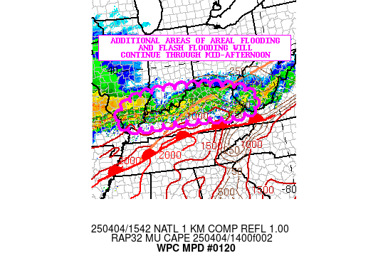
SUMMARY...Additional pockets of heavy rainfall may continue
through early this afternoon across areas of western and central
KY, with areas farther east across eastern KY and southern WV
seeing a continued slow improvement. Additional areas of areal
flooding and flash flooding will continue though in the near-term.

DISCUSSION...Radar imagery continues to show a west to east axis
of moderate to locally heavy rain associated with showers and
thunderstorms continuing to focus across the region to the north
of a returning warm front. Warm air advection/isentropic ascent
over this boundary along with the proximity of an elevated
instability gradient is a factor in maintaining the convective
threat and this continues to be aided by a persistent
south-southwest low-level jet of 30 to 40 kts.

The 12Z HREF guidance insists that the threat for heavy rains over
areas downstream involving eastern KY and southern WV should wane
going into the afternoon hours, however, there may still be some
localized persistence of convection with localized cell-training
concerns for areas of central and western KY including areas
closer to the OH River. A northward advance of some of the
convection is also expected to occur over southern IL and southern
IN which will need to be closely monitored.

Rainfall rates with the stronger storms still lingering over
western KY, and also overspreading parts of southern IL and
southern IN may exceed 1 inch/hour, with some additional spotty
rainfall amounts here of up to 2+ inches going through
mid-afternoon. All of these additional rains will only act to
prolong and exacerbate the ongoing areal flooding and flash
flooding situation across this portion of the OH Valley.

Orrison

ATTN...WFO...ILN...ILX...IND...JKL...LMK...LSX...MRX...PAH...
RLX...

ATTN...RFC...LMRFC...NCRFC...OHRFC...NWC...

LAT...LON   38868629 38798425 38378207 37578121 37158228
            37228348 37298580 37188869 37628964 38328920
            38708816
Download in GIS format: Shapefile
| KML
Last Updated: 1145 AM EDT Fri Apr 04 2025
