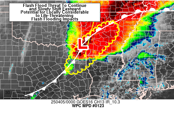
Mesoscale Precipitation Discussion 0123
NWS Weather Prediction Center College Park MD
821 PM EDT Fri Apr 04 2025

Areas affected...northeastern TX, ArkLaTex, into central AR

Concerning...Heavy rainfall...Flash flooding likely

Valid 050019Z - 050615Z

SUMMARY...Training of thunderstorms and flash flooding is likely
to continue from northeastern TX into central AR over the next few
hours. Rainfall rates within axes of training will contain 1-3
in/hr rates (but locally higher cannot be ruled out). Additional
rainfall totals of 3 to 6+ inches may occur within a narrow axis
from northeastern TX into southwestern AR through 06Z, potentially
causing considerable to life-threatening impacts.

DISCUSSION...00Z radar imagery showed a slow moving cluster of
heavy rain over northeastern TX, from north of I-20 into
southwestern AR. Colder cloud tops in GOES East infrared imagery
showed a classic appearance of a strongly divergent and diffluent
pattern in the upper levels. Observed rainfall rates within this
cluster have exceeded 3 in/hr at times and produced 5 to 6+ inches
of rain in the vicinity of Lindale, TX since ~21Z. This cluster of
thunderstorms was located along and just ahead of a slow moving
cold front, attached to a surface low in far southwestern AR. A
warm front extended northeastward from the low into far
southeastern MO and was being overrun by a strong 40-50 kt low
level jet.

The surface low is forecast to move northeastward into
north-central AR by 06Z, beginning an eastward push to the front
over central AR, but with little movement south of the AR/TX
border. As this occurs, the core of the 850 mb jet axis is
expected to nudge eastward to the MS Valley, but heavy rain
along/ahead of the front should remain a flash flood concern due
to training. Moderately strong MLCAPE values of 2000-3000 J/kg
(00Z SPC mesoanalysis) should lower a bit due to nocturnal
cooling, but remain more than sufficient for strong updrafts and
heavy rainfall production. Alignment of the front with the deeper
layer steering flow and only a slow eastward translation will set
up a dangerous pattern for very heavy rain on a localized basis
with potential for 2 to 3+ in/hr rates and 3 to 6+ inches of rain
over the next 6 hours.

Otto

ATTN...WFO...FWD...LZK...SHV...

ATTN...RFC...ABRFC...LMRFC...WGRFC...NWC...

LAT...LON   35649226 35459160 34609170 33439282 32139408
            31629519 32249561 33349493 34149447 34679376
            35179315
Download in GIS format: Shapefile
| KML
Last Updated: 821 PM EDT Fri Apr 04 2025
