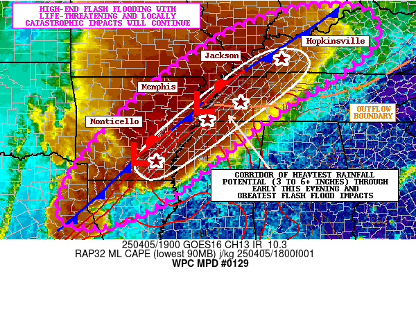
Mesoscale Precipitation Discussion 0129
NWS Weather Prediction Center College Park MD
315 PM EDT Sat Apr 05 2025

Areas affected...Lower MS Valley...Mid-South...Lower OH Valley

Concerning...Heavy rainfall...Flash flooding likely

Valid 051915Z - 060115Z

SUMMARY...Widespread flash flooding with continued areas of
training showers and thunderstorms will continue over the Lower MS
Valley, Mid-South and Lower OH Valley going into the evening
hours. High-end flash flooding with life-threatening and locally
catastrophic impacts will continue to be a likelihood.

DISCUSSION...Areas of extremely heavy rainfall will continue to
unfold over the next several hours as an elongated axis of
slow-moving and training showers and thunderstorms with high
rainfall rates impact large areas of the Lower MS Valley,
Mid-South and portions of the Lower OH Valley. The latest GOES-E
IR satellite imagery shows a very large and impressively
cold-topped convective canopy over the region, with dual-pol radar
showing some of the strongest convection and heaviest rainfall
rates associated with a QLCS stretching from southeast AR up
across western TN. Rainfall rates with this feature are well into
the 2 to 3 inch/hour range, and there has been at least some
southwest/northeast oriented training of this band of severe
convection.

No major changes to the large scale pattern are noted as the
convection continues to be driven by the gradual ejection of
mid-level troughing/shortwave energy across the southern Plains
with downstream interaction with a very moist and unstable 40 to
50+ kt southerly low-level jet focused along and out ahead of a
strong frontal zone. Multiple waves of low pressure continue to
transit the front which is yielding locally focused areas of
low-level convergence and forcing within an area that is broadly
divergent aloft.

MLCAPE along and south of this front and also a nearby outflow
boundary off to the east are on the order of 2000 to 3000 J/kg.
Enhanced shear profiles remain in place with robust 0-3km bulk
shear values of 50 to 60 kts which is favoring highly organized
and severe-mode convection including supercell development. This
very unstable/sheared environment coupled with very strong
moisture transport will continue to favor extremely heavy rainfall
rates in the 2 to 3 inch/hour range going through this evening as
the overall convective axis gradually settles down to the south
and east.

The experimental WoFS and HRRR guidance support additional
rainfall totals of as much as 3 to 6+ inches. Some of these
additional rains will locally overlap with areas of the Mid-South
and Lower OH Valley that are extremely sensitive and experiencing
ongoing flooding. This includes parts of eastern AR, western TN
and much of western KY. However, farther down to the south into
northern LA, far southeast AR and northern MS, the antecedent
conditions are notably drier with much higher FFG values.

Therefore, the high-end threat for significant flash flooding and
locally catastrophic impacts will continue to be over areas a bit
farther north, inclusive of multiple major metropolitan areas that
will see extreme rainfall potential. Areas farther south will be a
bit more conditional with the threat, but will also still likely
see flash flooding concerns with potential for significant impacts
given the extreme rainfall rate potential. Additional localized
Flash Flood Emergency level impacts overall remain a threat
heading into the evening hours, and this situation will continue
to be closely monitored.

Orrison

ATTN...WFO...HUN...ILN...IND...JAN...LMK...LSX...LZK...MEG...
OHX...PAH...SGF...SHV...

ATTN...RFC...ABRFC...LMRFC...NCRFC...OHRFC...SERFC...WGRFC...
NWC...

LAT...LON   38838648 38688465 37738437 36768538 35568736
            34398894 33149048 32299154 31699282 31479380
            31699485 32199497 33259453 34599348 36059201
            37209047 38198882
Download in GIS format: Shapefile
| KML
Last Updated: 315 PM EDT Sat Apr 05 2025
