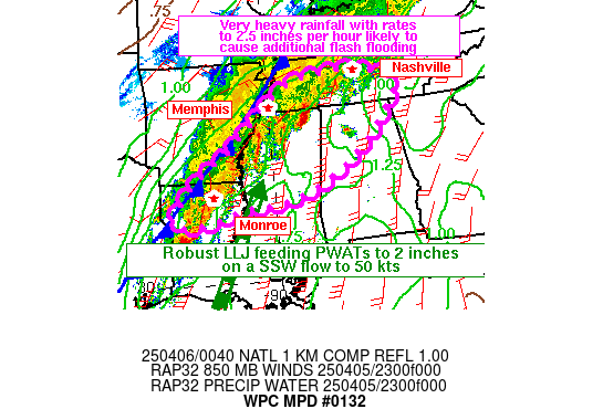
Mesoscale Precipitation Discussion 0132
NWS Weather Prediction Center College Park MD
843 PM EDT Sat Apr 05 2025

Areas affected...Portions of the Mid-South from Northern Louisiana
through Southern Tennessee

Concerning...Heavy rainfall...Flash flooding likely

Valid 060042Z - 060630Z

SUMMARY...Strong convection producing rates to 2.5 inches per hour
and training storms are likely to cause new flash flooding in many
areas that have been spared much rain from previous days. Flash
flooding likely with considerable flash flooding probable in areas
that have not received much rain in previous days.

DISCUSSION...Training storms moving NNE along a very slow moving
cold front are drawing abundant Gulf moisture from an impressively
robust 50 kt LLJ streaming parallel to the front. Individual cells
associated with the training storms have a history of producing
rainfall rates to 2 inches per hour. With the end of the diurnal
period, the typical strengthening of the LLJ should support the
strongest cells intensifying further through the evening as they
are very efficiently using warm rain processes to result in these
very high rainfall rates.

CAMs guidance has been very slow with these storms further to the
north, but the lack of eastward progress in this portion of the
South has been in decent agreement in the CAMs, which supports the
aforementioned strengthening of the storms as the LLJ
reintensifies.

Fortunately, all of the storms with the highest rainfall rates now
have moved south and east of the areas that have been hit hardest
by the heavy rains over the past 3 days. Thus, they are moving
over areas now with significantly higher FFGs and soils that are
far more capable of absorbing at least some of the heavy rainfall
before it converts to runoff as compared with areas north and west
in the stratiform rain. Northern and western areas of the MPD area
that have moved to stratiform rain have been hard hit in recent
days, and the stratiform rain, while much lower in overall rates,
will still completely convert to additional runoff, and will
contribute to continued flash flooding.

Wegman

ATTN...WFO...BMX...HUN...JAN...LZK...MEG...MRX...OHX...SHV...

ATTN...RFC...LMRFC...OHRFC...SERFC...WGRFC...NWC...

LAT...LON   36058677 35878615 35568538 35108553 33898660
            32828815 32278975 32209091 31849229 31749325
            31959365 33179259 33929149 35698928
Download in GIS format: Shapefile
| KML
Last Updated: 843 PM EDT Sat Apr 05 2025
