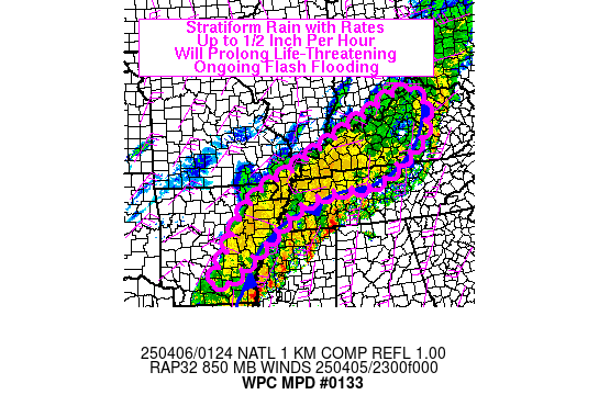
Mesoscale Precipitation Discussion 0133
NWS Weather Prediction Center College Park MD
927 PM EDT Sat Apr 05 2025

Areas affected...Lower Ohio and Mid-Mississippi Valleys

Concerning...Heavy rainfall...Flash flooding likely

Valid 060126Z - 060530Z

SUMMARY...Stratiform rain with rainfall rates up to a half inch
per hour is prolonging ongoing life-threatening flash flooding
across northeast Arkansas, northern Tennessee, and western
Kentucky.

DISCUSSION...An area of stratiform rain on the northern and
western edge of the moisture plume and convection producing
incredibly heavy rainfall across northern Louisiana, Mississippi,
and southern Tennessee will continue to weaken and dissipate from
northwest to southeast through the evening hours. Heavy rain is no
longer expected in this area, but the stratiform rain ongoing in
this area is likely to continue for the next several hours for
southern and eastern portions of this MPD area, and should end
within the next hour of northern and western areas.

This stratiform rain is producing rainfall rates of up to a half
inch per hour, and for many areas is less than a quarter of an
inch per hour. While this alone would not be discussion-worthy,
given the many reports of a foot or more of rain over the past 3
days, much of which fell earlier today, even this light rain is
prolonging ongoing life-threatening flash flooding across much of
this region. As the convection causing the stratiform rain shifts
to the south, so too will the stratiform. FFGs in this entire MPD
region are less than a half inch per hour, and in many areas under
a quarter of an inch per hour, so even this rain is sufficient to
prolong and in some areas perhaps worsen ongoing flooding. Drier
air impinging on the precipitation shield from the north should
continue eroding the precipitation shield, which will finally
fully and completely end this historic rainfall event across this
area.

Wegman

ATTN...WFO...ILN...LMK...LZK...MEG...OHX...PAH...

ATTN...RFC...ABRFC...LMRFC...OHRFC...NWC...

LAT...LON   38798478 38758475 38528444 38078433 37488448
            36968508 36148647 36098690 36018851 35568966
            34899052 34839053 34359118 33749192 33539240
            33729268 34449212 35259166 35569142 36089088
            36489021 36888923 37428821 37678763 37898714
            38208641 38628553 38798509
Download in GIS format: Shapefile
| KML
Last Updated: 927 PM EDT Sat Apr 05 2025
