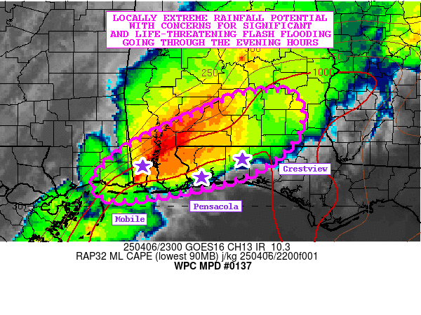
Mesoscale Precipitation Discussion 0137
NWS Weather Prediction Center College Park MD
712 PM EDT Sun Apr 06 2025

Areas affected...Coastal MS...Southern AL...Western FL Panhandle

Concerning...Heavy rainfall...Flash flooding likely

Valid 062310Z - 070410Z

SUMMARY...Training bands of showers and thunderstorms will
continue through the evening hours which will include locally
significant and life-threatening flash flooding concerns from
extreme rainfall rates.

DISCUSSION...GOES-E IR satellite imagery shows an extensive axis
of cold-topped convection impacting portions of coastal MS through
southwest AL. This corridor of heavy shower and thunderstorm
activity is embedded within a divergent flow regime aloft with a
combination of right-entrance region upper jet dynamics and
shearing vort energy interacting with a moist and unstable
south-southwest low-level jet.

The latest area VWP data shows a convergent low-level jet on the
order of 30 to 40+ kts with some of the strongest moisture
convergence magnitudes situated across coastal MS/AL and the far
western parts of the FL Panhandle. MLCAPE values of 1500+ J/kg are
noted across this region with relatively strong shear parameters
(effective bulk shear of 40+ kts) still favoring organized
updrafts and a sustainable axis of convection.

Significant concerns for cell-training will exist through the
evening hours as this convection tends to maintain itself out
ahead of a cold front slowly approaching from the west. While the
overall instability may begin to slowly decrease in magnitude,
there will likely still be sufficient low-level
forcing/convergence and modest jet support aloft for convection to
continue over the next several hours albeit perhaps occasionally
in a broken fashion. Smaller scale bands of training convection
are expected to continue though locally.

Given the thermodynamic and kinematic environment, and level of
moisture transport off the Gulf, the rainfall rates will continue
to be locally extreme in nature, with rates as high as 2 to 4
inches/hour. Already areas around the Mobile, AL metropolitan area
and adjacent suburbs have been seeing these high rates over the
last couple of hours. In fact, just in the last hour, the Downtown
Mobile (KBFM) ASOS reported 3.17 inches of rain!

The latest HRRR guidance suggests high-end rainfall potential
going through the mid to late-evening hours, with additional
rainfall totals of 4 to 6 inches possible, with isolated heavier
amounts. The 12Z ARW/ARW2 solutions of the HREF suite have a
similar footprint, but are likely a bit too far to the north
considering the latest observational trends.

Given these solutions and the latest radar and satellite trends,
it seems rather likely that some portions of southwest and
southern AL in particular, and the far western parts of the FL
Panhandle will have a period of extreme rainfall over the next few
hours at least.

Consequently, flash flooding is likely to continue through the
evening hours, including potentially significant and
life-threatening impacts.

Orrison

ATTN...WFO...BMX...LIX...MOB...TAE...

ATTN...RFC...LMRFC...SERFC...NWC...

LAT...LON   31878642 31848563 31178560 30548641 30208782
            30138870 30438895 31008836 31618709
Download in GIS format: Shapefile
| KML
Last Updated: 715 PM EDT Sun Apr 06 2025
