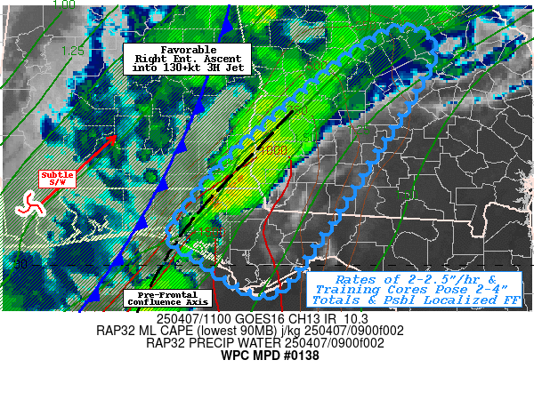
Mesoscale Precipitation Discussion 0138
NWS Weather Prediction Center College Park MD
715 AM EDT Mon Apr 07 2025

Areas affected...Central FL Panhandle...Southwest GA...Far
Southeast AL...

Concerning...Heavy rainfall...Flash flooding possible

Valid 071115Z - 071630Z

SUMMARY...Slow moving pre-frontal band with embedded training
cores pose localized 2-4" totals in 1-3 hours.  Flash flooding
possible.

DISCUSSION...GOES-E WV suite depicts a broad right entrance region
of to 130+kt 3H Jet across the area of concern as the jet lifts
through the central Ohio Valley in the next few hours.  A weak
surface low across NW GA is shepherding along a slow moving cold
front that now extends southward across SE AL into the far W FL
panhandle into the central Gulf.  Along/ahead of the boundary the
instability axis is nosed northward into SW GA with 500+ MLCAPE as
far north as Columbus, GA increasing to 1500+ along the central
Gulf Coast, this while the moisture axis remains pooled mainly
through depth along and just anafrontal.  However, there is a
viable overlap location along a pre-frontal surface to boundary
layer wind confluence and pressure trough.  The combination of
factors as resulted in sufficient convective development of a
broadening band of thunderstorms from Washington county, FL to
Houston county, AL toward Calhoun county, GA.   Moisture through
depth results in 1.75" total PWats, however, sfc-850mb LPW
supported by low 70s Tds suggest the bulk of that is being fluxed
into the confluent line at 15kts near surface to 35kts near cloud
base with solid 15-30 degrees of confluence.

As such, rates of 2"/hr occasionally ticking up to 2.5" are
becoming more common along the line into SE AL.  Furthermore, the
flow above the boundary layer is providing fairly unidirectional
flow for training nearly parallel to the slow advancing frontal
zone.  This allows for increased duration, especially as upstream
redevelopment is occurring well into the Gulf.   While the front
is providing some slow eastward propagation this may allow for 1-2
hours of heavy rainfall and may result in localized 2-4" totals,
with highest totals more likely near the stronger flux and higher
unstable air near the Gulf, though potential to extend further
inland is expected as instability axis is forecast to shift
northward as well.   FFG values seem to decrease from coast inward
to SW GA, to pose a similar potential of exceedance though the
line...but not continuously so.  As such, flash flooding is
considered possible and likely to be widely scattered to scattered
in nature, and per usual greater near urban and traditional prone
locations.

Gallina

ATTN...WFO...FFC...TAE...

ATTN...RFC...SERFC...NWC...

LAT...LON   33078300 32688277 31288362 30238431 29638483
            29828542 30168584 30388616 31208554 31878483
            32848365
Download in GIS format: Shapefile
| KML
Last Updated: 715 AM EDT Mon Apr 07 2025
