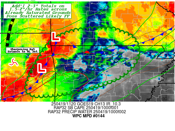
Mesoscale Precipitation Discussion 0144
NWS Weather Prediction Center College Park MD
737 AM EDT Sat Apr 19 2025

Areas affected...Northwest AR...Southwest MO....Far Eastern OK....

Concerning...Heavy rainfall...Flash flooding likely

Valid 191135Z - 191700Z

SUMMARY...Another round of strong thunderstorms crossing recently
saturated/flooded grounds increasing the potential for flash
flooding through early morning.

DISCUSSION...10z Surface analysis depicts a complex analysis with
old outflow boundaries/mixed air with exiting meso-high across MO
into NE OK.  To add to the complexity, a sharpening upper-level
right jet entrance region is lifting north across central OK into
E OK/W KS resulting in falling pressures downstream across SW MO
backing low level flow and increasing deep layer moisture flux
convergence.  This shortwave DPVA/Upper-level divergence ascent
pattern is noted well in the GOES-E WV suite, with numerous
overshooting cooling tops breaking through the cirrus canopy
across E OK starting to encroach on SW MO/NW AR.  CIRA LPW backed
up by RAP analysis denotes a slug of enhanced deep layer moisture
up to 1.75", along and downstream of the shortwave to increasing
rainfall production/efficiency over the next few hours.   Early
morning convection limiting factor is typically lack of
instability; however, a well of mid 70s Temps over mid to upper
60s Tds and solid lapse rates does support along stream
instability with SBACAPEs of 1000-1500 J/kg from SE OK to
W-central AR, likely to be advected northward across the old
outflow boundary/cold front.  The source is not very large and may
limit coverage and/or duration of convective activity but should
be sufficient to support 1.5-2"/hr rates.

The growing concern is the overlap/intersection with already
saturated/flooded ground conditions across NW AR and so potential
of an additional 2-3" (mainly in less than 1-1.5hrs) will likely
result in flash flooding conditions in a few spots, but the
expansion of the area/source of instability will allow for
southward and eastward propagation an may expand the areal
coverage for flash flooding over the coming hours.  Further
diurnal stabilization toward late morning will likely reduce
intensity with loss/usage of remaining unstable air and
coverage/intensity should decrease toward 16-17z and into
south-central MO/northeast AR.

Gallina

ATTN...WFO...LZK...SGF...TSA...

ATTN...RFC...ABRFC...LMRFC...MBRFC...NWC...

LAT...LON   37189238 37069184 36809132 36249113 35729134
            35189203 34799318 34609408 34529487 34579543
            34979555 35969508 36699454 37099363
Download in GIS format: Shapefile
| KML
Last Updated: 737 AM EDT Sat Apr 19 2025
