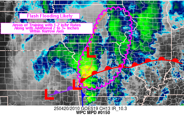
Mesoscale Precipitation Discussion 0150
NWS Weather Prediction Center College Park MD
427 PM EDT Sun Apr 20 2025

Areas affected...MO into eastern IA and far western IL

Concerning...Heavy rainfall...Flash flooding likely

Valid 202026Z - 210220Z

Summary...Heavy rain will translate north-northeast from MO into
IA through 02Z with embedded rainfall rates of 1-2 in/hr due to
training. Flash flooding is expected (especially across wet
antecedent conditions) from an additional 2-3 inches, although 3+
cannot be completely ruled out.

Discussion...20Z surface observations placed a triple point
surface low along the southern KS/MO border with a cold front
extending southward from the low into western AR and a warm front
extending ENE across central MO. An inverted trough extended north
from the triple point low through western MO into central IA with
an attached surface low near CDJ. A convective line was
propagating eastward ahead of the cold front through southwestern
MO into a region of saturated soils due to 4 to 8 inches of rain
over the past 2 days. Farther north, surface convergence along the
inverted trough and slightly elevated low level convergence at the
nose of 35-50 kt 925-850 mb winds were aiding the placement of a
SW to NE axis of thunderstorms extending across north-central MO,
with periods of training ongoing.

As a potent mid-level shortwave tracks northeastward from the
central KS/OK border to the east-central IA/MO border over the
next 6 hours, the triple point low will follow a similar path with
low level convergence sustaining thunderstorms ahead of the
inverted surface trough in a SW to NE fashion (at least early on).
Increasing divergent and diffluent flow aloft within the right
entrance region of an upper level jet streak over western IA will
overlap the low level convergence yielding strong ascent. Steering
flow oriented SSW to NNE will support training along this low
level convergence axis ahead of the triple point low with rainfall
rates of 1-2 in/hr. Farther south, closer to the warm front's 20Z
position, additional rainfall should be lighter due to the
progressive nature of the convective line, with perhaps an
additional 1 to 1.5 inches max over the next few hours.

The greater concern for flash flooding will be over central MO due
to recent heavy rain, followed by locations from northern MO into
eastern IA where training is likely to produce an additional 2-3
inches along a fairly narrow axis. While a lack of recent rainfall
has northern MO into southern IA with limited soil moisture values
per NASA SPoRT imagery, flash flood guidance is as low as 1.5 to
2.5 inches in 3 hours and is likely to be surpassed in a few
locations.

Otto

ATTN...WFO...ARX...DMX...DVN...EAX...LSX...SGF...

ATTN...RFC...ABRFC...MBRFC...NCRFC...NWC...

LAT...LON   42959099 41549071 39919100 38339169 37689236
            37249332 37319402 37749442 38639448 39329435
            40759361 42909264
Download in GIS format: Shapefile
| KML
Last Updated: 427 PM EDT Sun Apr 20 2025
