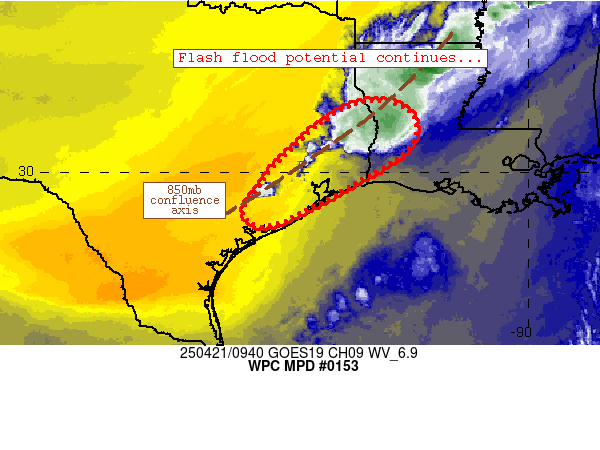
Mesoscale Precipitation Discussion 0153
NWS Weather Prediction Center College Park MD
552 AM EDT Mon Apr 21 2025

Areas affected...southeast Texas, far southwest Louisiana

Concerning...Heavy rainfall...Flash flooding possible

Valid 210950Z - 211400Z

Summary...Local/spotty flash flood potential should continue for
at least another 2-3 hours.

Discussion...Convection continues to fire along an 850mb
confluence axis extending from north-central Louisiana through
southeast Texas.  Along and ahead of this confluence axis, 1000
J/kg MLCAPE and 1.7 inch PW values were combining with favorable
kinematics for slow-moving storms with locally extreme rain rates.
 In fact, MRMS estimates approximately 6.5 inches of rain in
southern Tyler County over the past 3 hours.  Nearby convection
has also produced 1-2 inch/hr rain rates at times.  Recent radar
mosaic imagery also depicts an uptick in weaker convection from
Tyler County westward and southwestward through Colorado County,
suggestive of a continued flash flood threat in these areas over
at least the next 2-3 hours.

Convective coverage becomes a bit less certain after 13Z or so.
Although confluence will remain in place across the discussion
area through that time, RAP/SPC Mesoanalyses depict
weakening/slackening 850mb flow east of the confluence zone that
could cause existing updrafts to struggle against conditional
instability aloft.  The timing of this scenario is a bit
uncertain, however, and recent CAMs maintain convection across the
discussion area (perhaps propagating and/or developing toward
coastal areas) through at least 15-16Z or so.  This area will be
re-evaluated for any continuing flash flood potential (and another
MPD) after ~13-14Z or so.

Cook

ATTN...WFO...HGX...LCH...SHV...

ATTN...RFC...LMRFC...WGRFC...NWC...

LAT...LON   31669341 31289269 30569280 29899379 29159515
            28739615 29059666 29829618 30479560 31419444
Download in GIS format: Shapefile
| KML
Last Updated: 552 AM EDT Mon Apr 21 2025
