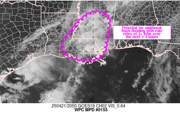
Mesoscale Precipitation Discussion 0155
NWS Weather Prediction Center College Park MD
508 PM EDT Mon Apr 21 2025

Areas affected...southern MS into southeastern LA

Concerning...Heavy rainfall...Flash flooding possible

Valid 212107Z - 220110Z

Summary...Training/backbuilding cells will continue a flash flood
threat for portions of southeastern LA into southern MS through
01Z. Localized high rainfall rates in excess of 3 in/hr will be
possible.

Discussion...Visible satellite and regional radar imagery at 2045Z
showed scattered thunderstorms extending from south-central MS
into southeastern LA, with low level moisture feeding an unstable
(1000-2000 J/kg MLCAPE) and moist (1.5 to 1.7 inch PWATs) airmass
into the region via southerly 10-15 kt 925-850 mb winds. Given
similarly oriented and slightly weaker deeper layer steering flow,
elements of training and backbuilding have been observed near
downtown New Orleans and the I-10 corridor to the west. Several
reports of rainfall rates exceeding 1 inch in 15 minutes and 3
inches per hour have been observed in this area of LA.

Aloft, initiation was augmented by lift ahead of a subtle
shortwave aloft over the western Gulf and an upper level jet max
crossing northern Mexico and southern TX, with divergence and
diffluence focused over the lower MS Valley. Similar broader scale
flow and ascent will remain in place over the next few hours with
continued potential for training/backbuilding existing across a
wider region than just the New Orleans metro, though coverage of
very high rainfall rates may be limited in scope.

While flash flooding is ongoing across portions of southeastern
LA, some uncertainty exists with the longevity of cells over the
New Orleans metro given the potential for exhausting of
instability. The development of additional flash flood producing
rainfall across other locations is also a bit uncertain. While the
setup favors rainfall rates over 3 in/hr expanding to the west and
north of New Orleans, high flash flood guidance of 3 to 4+ inches
per hour is in place for southern portions of the lower MS Valley
so any additional flash flooding may be limited to urban locations
where infiltration of water will be slowed.

Otto

ATTN...WFO...JAN...LCH...LIX...MOB...

ATTN...RFC...LMRFC...NWC...

LAT...LON   32959013 32958936 32668890 31998885 30738906
            29918927 29439021 29599150 29899210 30629233
            31419172 32239112
Download in GIS format: Shapefile
| KML
Last Updated: 508 PM EDT Mon Apr 21 2025
