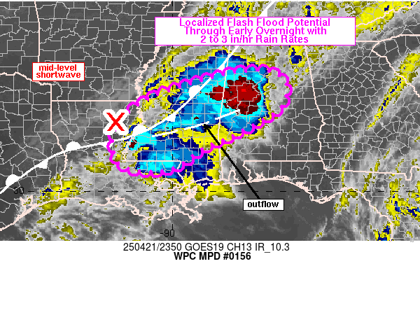
Mesoscale Precipitation Discussion 0156
NWS Weather Prediction Center College Park MD
810 PM EDT Mon Apr 21 2025

Areas affected...northeastern LA into central MS/AL

Concerning...Heavy rainfall...Flash flooding possible

Valid 220009Z - 220530Z

SUMMARY...Isolated flash flooding will be possible over the next
3-5 hours from northeastern LA into central MS and central AL.
Potential will exist for training and rainfall rates of 2-3 in/hr
with totals up to 5 inches, although coverage of these higher
rainfall totals should be quite limited if they do occur.

DISCUSSION...Scattered to numerous thunderstorms were ongoing from
the central LA/MS border into central MS and western AL at 00Z,
near and south of a quasi-stationary front. SPC mesoanalysis data
from 23Z showed MLCAPE across the region was 1000-1500 J/kg with
1.5 to 1.8 inches of precipitable water. Water vapor imagery
showed a shortwave over northern LA, beginning to advance
northeastward into MS, and recent cooling of cloud tops near
Natchez, MS may be a result of ascent ahead of the advancing
shortwave.

Farther east, existing convection along the MS/AL border has
produced a rain-cooled boundary within the warm sector of the
stationary front and subtle enhancement of 925-850 mb winds ahead
of the shortwave are forecast through 03Z which should support
increased overrunning of the front and rain-cooled outflow
boundary. Per radar imagery, mean storm motions were off toward
the northeast at 10 to 20 kt (locally higher), quasi-parallel to
initiating boundaries which could promote some training and brief
backbuilding of storms over the next few hours. Favorably
diffluent flow aloft was, and will continue to be, in place within
the broad left-exit region of a jet max positioned over
south-central TX, which should aid with lift across the lower MS
Valley and just downstream.

While the environment is moist, diurnal cooling and convective
overturning will contribute to some loss in instability overnight,
which means coverage of convection may be near its max at the
present time across the broader LA/MS?AL region. Nonetheless, some
flash flood threat will continue into the first half of the
overnight with rates of 2-3 in/hr easily attainable within the
favorable environment with potential for additional development.
However, limited coverage of these higher rates and generally high
flash flood guidance for the region should limit the areal extent
of any flash flooding that might develop.

Otto

ATTN...WFO...BMX...HUN...JAN...LCH...LIX...MEG...MOB...SHV...

ATTN...RFC...LMRFC...SERFC...NWC...

LAT...LON   34028735 33748629 32798640 31858799 31458898
            30729009 30769152 31229190 31999192 32839120
            33508968
Download in GIS format: Shapefile
| KML
Last Updated: 810 PM EDT Mon Apr 21 2025
