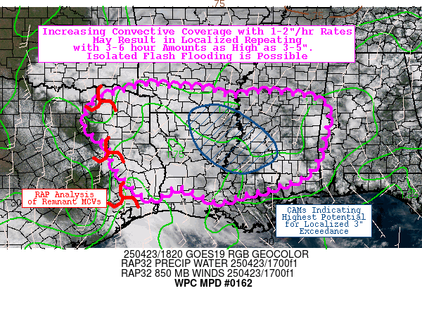
Mesoscale Precipitation Discussion 0162
NWS Weather Prediction Center College Park MD
240 PM EDT Wed Apr 23 2025

Areas affected...Ark-La-Tex and East TX through southern and
central MS

Concerning...Heavy rainfall...Flash flooding possible

Valid 231900Z - 240100Z

Summary...Increasing convective coverage through the late
afternoon and evening with relatively slow storm motions will
result in widely scattered hourly totals of 1-2". Localized
repeating of efficient rainfall rates may result in 3-6 hour
totals as high as 3-5" (highest chances in the vicinity of the
MS/LA border region). Isolated/localized flash flooding is
possible.

Discussion...Diurnally driven showers and thunderstorms are
increasing in coverage (once again) this afternoon across a
relatively weakly forced, moderately unstable and moist
environment from the Ark-La-Tex through southern and central MS.
One cluster of scattered to numerous is occurring across portions
of southern MS and southeast LA, while another is occurring closer
to the Ark-La-Tex. Most storms have been relatively shallow thus
far (due to some capping between 850-600 mb), but updrafts in the
vicinity of the MS/LA border have begun to reach the LFC in the
past hour or two. Meanwhile, cloud cover associated with remnant
MCVs (from overnight convection across TX) has moved into the
Ark-La-Tex and points south, which has largely suppressed deeper
updrafts (so far). DPVA in association with these MCVs may help to
eventually organized convection (along with associated remnant
upper-level divergence associated with the MCVs, as well as being
on the periphery of modest divergence in association with the left
exit region of a subtropical jet streak near the TX and Mexico
border). The commonality between both areas is relatively weak
southerly low-level flow (primarily guiding storm motions) with
925-850 mb winds between 10-20 kts (and upwind propagation vectors
as weak as 5 kts, generally towards the southeast). In addition,
PWATs generally range from 1.3-1.7 inches (near 90th percentile)
with ML CAPE of 1000-2000 J/kg. Slower storm motions with the
potential for localized backbuilding, outflow boundary collisions,
and cell mergers should present the potential for localized
repeating of 1-2" rainfall rates/hourly totals.

While individual CAMs (including the 12z HREF, 06z RRFSe, and
hourly HRRR/RRFS) all seem to depict varying degrees of randomized
scattered coverage of highly localized 2-5" totals, some
interesting tidbits can be gleaned from the post-processed
statistical output. Both ensemble suites depict high odds (40-80%)
for localized 2" exceedance (per 40-km neighborhood method) and
medium odds (20-50%) for localized 3" exceedance. While 2"
exceedance probs are widespread across the region, there is
distinct clustering in the vicinity of the MS/LA border region for
3" exceedance probs (with the HREF lagging the RRFSe for the
relevant time frame, indicating 21z-03z peak vs. 18z-00z peak).
While 3-6 hour FFGs typically range from 3.0-5.0", prior days
rainfall has resulted in localized sensitivities with FFGs as low
as 2.0-3.0". Isolated/localized flash flooding is possible.

Churchill

ATTN...WFO...BMX...FWD...HGX...JAN...LCH...LIX...LZK...MOB...
SHV...

ATTN...RFC...ABRFC...LMRFC...SERFC...WGRFC...NWC...

LAT...LON   33919418 33849314 33779211 33529139 33649055
            33638952 33288826 32258830 31098873 30588987
            30369082 30119156 30149201 30589314 30169409
            31129511 31949546 32549618 33399584 33729488
Download in GIS format: Shapefile
| KML
Last Updated: 241 PM EDT Wed Apr 23 2025
